Hanging Bridge: Difference between revisions
Created page with "{{Infobox bridge |name=Hanging Bridge |county=Lancashire |town=Manchester |picture=Hanging Bridge 1892.jpg |picture caption=Hanging Bridge as excavated in 1892 |os grid ref=SJ..." |
m →top: clean up, replaced: medieval → mediæval (2) |
||
| (One intermediate revision by one other user not shown) | |||
| Line 14: | Line 14: | ||
|carries= | |carries= | ||
}} | }} | ||
'''Hanging Bridge''' is a | '''Hanging Bridge''' is a mediæval bridge spanning the Hanging Ditch, which connected the rivers [[River Irk|Irk]] and [[River Irwell|Irwell]] in [[Manchester]], [[Lancashire]].<ref>{{cite web |title=The Hanging Bridge |url=http://www.mcvc.info/?s=bridge |publisher=Manchester Cathedral Visitor Centre |accessdate=7 October 2008 }}</ref> The first reference to the bridge was in 1343, when it was called ''Hengand Brigge'',<ref name=Cooper51>{{Harvnb|Cooper|2003|p=51.}}</ref> but the present structure was built in 1421, replacing an earlier bridge.<ref name=ps/> Material taken from Manchester's Roman fort may have been used in its construction.<ref name=h3>{{Harvnb|Hylton|2003|p=3}}</ref> It has been speculated that the Hanging Ditch may be of Roman origin, part of a defensive circuit between the rivers [[River Irk|Irk]] and [[River Irwell|Irwell]].<ref>{{Harvnb|Gill|1890|pp=98–99}}</ref> | ||
At its Irwell end, the Hanging Ditch was 120 feet wide and 40 feet deep. A stream flowed through the ditch, from the Irk to the Irwell; possibly the lost River Dene, which gave its name to Deansgate.<ref name=Cooper52>{{Harvnb|Cooper|2003|p=52}}</ref> The bridge has two arches and was built using sandstone from [[Collyhurst]].<ref name=ps/> It is 108 feet long and 9 feet wide.<ref name=Cooper51 /> The bridge formed part of Manchester’s | At its Irwell end, the Hanging Ditch was 120 feet wide and 40 feet deep. A stream flowed through the ditch, from the Irk to the Irwell; possibly the lost River Dene, which gave its name to Deansgate.<ref name=Cooper52>{{Harvnb|Cooper|2003|p=52}}</ref> The bridge has two arches and was built using sandstone from [[Collyhurst]].<ref name=ps/> It is 108 feet long and 9 feet wide.<ref name=Cooper51 /> The bridge formed part of Manchester’s mediæval defences, when it was the main route from Manchester to [[Manchester Cathedral|the cathedral]], then a parish church.<ref name=ps/> | ||
==Hidden and rediscovered== | ==Hidden and rediscovered== | ||
| Line 29: | Line 29: | ||
{{Reflist|colwidth=30em}} | {{Reflist|colwidth=30em}} | ||
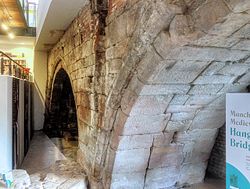
[[File:Manchester's Hanging Bridge in the Cathedral refectory- geograph-4567159.jpg|right|thumb|250px|The bridge today, in the Cathedral refectory]] | |||
{{Refbegin}} | {{Refbegin}} | ||
*{{Cite journal |last=Gill |first=Richard |title=The Hanging Bridge, Manchester |journal= Transactions of Lancashire and Cheshire Antiquarian Society |year=1890 |volume=VIII |pages=97–111 |ref=harv |postscript=<!--None-->}} | *{{Cite journal |last=Gill |first=Richard |title=The Hanging Bridge, Manchester |journal= Transactions of Lancashire and Cheshire Antiquarian Society |year=1890 |volume=VIII |pages=97–111 |ref=harv |postscript=<!--None-->}} | ||
Latest revision as of 10:55, 30 January 2021
| Hanging Bridge | |
| Lancashire | |
|---|---|
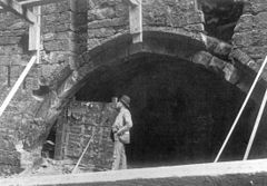
 Hanging Bridge as excavated in 1892 | |
| Location | |
| Crossing: | Hanging Ditch |
| Location | |
| Grid reference: | SJ838986 |
| Location: | 53°29’4"N, 2°14’36"W |
| Structure | |
| History | |
| Built 1421 | |
| Information | |
Hanging Bridge is a mediæval bridge spanning the Hanging Ditch, which connected the rivers Irk and Irwell in Manchester, Lancashire.[1] The first reference to the bridge was in 1343, when it was called Hengand Brigge,[2] but the present structure was built in 1421, replacing an earlier bridge.[3] Material taken from Manchester's Roman fort may have been used in its construction.[4] It has been speculated that the Hanging Ditch may be of Roman origin, part of a defensive circuit between the rivers Irk and Irwell.[5]
At its Irwell end, the Hanging Ditch was 120 feet wide and 40 feet deep. A stream flowed through the ditch, from the Irk to the Irwell; possibly the lost River Dene, which gave its name to Deansgate.[6] The bridge has two arches and was built using sandstone from Collyhurst.[3] It is 108 feet long and 9 feet wide.[2] The bridge formed part of Manchester’s mediæval defences, when it was the main route from Manchester to the cathedral, then a parish church.[3]
Hidden and rediscovered

In 1600 the Hanging Ditch was condemned as an unsanitary open sewer, and in the following years the ditch was culverted and the bridge buried and built over. A directory published in 1772 recorded that nine houses had been built along the line of the bridge, suggesting that it may have been covered over during the first phase of Manchester's town planning, at some time in the 1770s.[6] The bridge was then forgotten, remembered only in the name of the area where it had stood.
However, in the 1880s, demolition work on buildings by the old ditch was carried and the Hanging Bridge was rediscovered. The bridge was put on display, and in three months had about 32,000 paying visitors. It was once again covered up during the Victorian expansion of Manchester. More than 100 years later it was uncovered again, and following restoration work it went on display in 2002 as a main attraction of Manchester Cathedral's newly built visitor centre.[7]
Today the bridge is largely hidden by modern buildings, but it can be seen in the basement of Manchester Cathedral Visitor Centre, where it forms one side of the refectory.[8] The bridge is listed as a Scheduled Ancient Monument.[3]
References
- ↑ "The Hanging Bridge". Manchester Cathedral Visitor Centre. http://www.mcvc.info/?s=bridge. Retrieved 7 October 2008.
- ↑ 2.0 2.1 Cooper 2003, p. 51.
- ↑ 3.0 3.1 3.2 3.3 National Monuments Record: No. 76682 – Hanging Bridge
- ↑ Hylton 2003, p. 3
- ↑ Gill 1890, pp. 98–99
- ↑ 6.0 6.1 Cooper 2003, p. 52
- ↑ "Bridge to Manchester's past revealed". BBC. 18 December 2001. http://news.bbc.co.uk/1/hi/uk/england/1717912.stm. Retrieved 4 April 2008.
- ↑ Cooper 2003, pp. 53–54

- Gill, Richard (1890). "The Hanging Bridge, Manchester". Transactions of Lancashire and Cheshire Antiquarian Society VIII: 97–111
- Cooper, Glynis (2003). Hidden Manchester. Breedon Books Publishing. ISBN 1-85983-401-9
- Hylton, Stuart (2003). A History of Manchester. Chichester: Phillimore and co. Ltd.. ISBN 1-86077-240-4