Difference between revisions of "Holbeach Drove"
From Wikishire
(Created page with "{{Infobox town |name=Holbeach Drove |county=Lincolnshire |picture=St Polycarp's Church, Holbeach Drove - geograph.org.uk - 177300.jpg |picture caption=St Polycarp, Holbeach D...") |
(→Outside links) |
||
| Line 22: | Line 22: | ||
{{commons}} | {{commons}} | ||
| + | {{Holbeach}} | ||
{{stub}} | {{stub}} | ||
Latest revision as of 13:04, 6 October 2020
| Holbeach Drove | |
| Lincolnshire | |
|---|---|
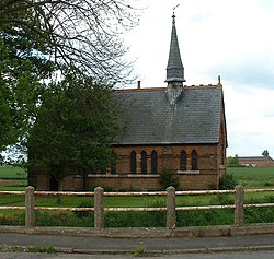
 St Polycarp, Holbeach Drove | |
| Location | |
| Grid reference: | TF326123 |
| Location: | 52°41’35"N, 0°2’18"W |
| Data | |
| Post town: | Spalding |
| Postcode: | PE11 |
| Dialling code: | 01406 |
| Local Government | |
| Council: | South Holland |
| Parliamentary constituency: |
South Holland and The Deepings |
Holbeach Drove is a village in Holland, the south-eastern part of Lincolnshire, situated about five miles east of Crowland, and at the junction of the B1166 and the B1168 roads.
The village church is dedicated to St Polycarp.
There is one local public house, the Golden Ball, and a shop-cum-petrol station.
Outside links
| ("Wikimedia Commons" has material about Holbeach Drove) |
| Holbeach and Holbeach Marsh, in Lincolnshire |
|---|
|
Holbeach • Holbeach Bank • Holbeach Clough • Holbeach Drove • Holbeach Fen • Holbeach Hurn • Holbeach Marsh • Holbeach St Johns • Holbeach St Marks • Holbeach St Matthew |