Saunders Island, South Sandwich Islands: Difference between revisions
mNo edit summary |
No edit summary |
||
| (2 intermediate revisions by the same user not shown) | |||
| Line 4: | Line 4: | ||
|territory=South Georgia and the South Sandwich Islands | |territory=South Georgia and the South Sandwich Islands | ||
|group=South Sandwich Islands | |group=South Sandwich Islands | ||
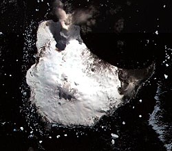
|picture= | |picture=Saunders Island ASTER.jpg | ||
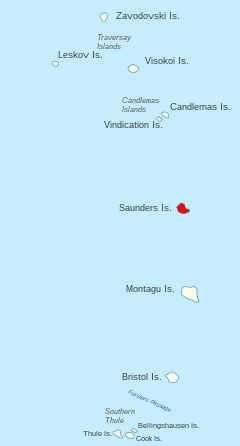
|map= | |map=Saunders Island - South Sandwich Islands.svg | ||
|map caption= | |map caption=Location of Saunders Island | ||
|longitude=-57.7833 | |longitude=-57.7833 | ||
|latitude=-26.45 | |latitude=-26.45 | ||
| Line 20: | Line 20: | ||
==References== | ==References== | ||
{{reflist}} | {{reflist}} | ||
*{{basgaz|Saunders Island}} | |||
*{{cite book | last=LeMasurier | first=W. E. | coauthors=Thomson, J. W. (eds.) | title=Volcanoes of the Antarctic Plate and Southern Oceans | publisher=American Geophysical Union | date=1990 | isbn=0-87590-172-7 | page=512 pp }} | *{{cite book | last=LeMasurier | first=W. E. | coauthors=Thomson, J. W. (eds.) | title=Volcanoes of the Antarctic Plate and Southern Oceans | publisher=American Geophysical Union | date=1990 | isbn=0-87590-172-7 | page=512 pp }} | ||
*[http://volcano.und.edu/vwdocs/volc_images/south_america/mt_michael.html Volcano World: Mount Michael] | *[http://volcano.und.edu/vwdocs/volc_images/south_america/mt_michael.html Volcano World: Mount Michael] | ||
{{SGSSI}} | {{SGSSI}} | ||
{{catself}} | |||
Latest revision as of 19:58, 7 June 2020
- Not to be confused with Saunders Island, Falkland Islands
| Saunders Island | |
|
South Sandwich Islands
| |
|---|---|

| |
| Location | |
| Location: | 26°27’-0"S, 57°46’60"W |
| Highest point: | Mount Michael, 3,248 feet |
| Data | |
| Population: | Uninhabited |
Saunders Island is a crescent-shaped island 5½ miles long, lying between Candlemas Island and Montagu Island in the South Sandwich Islands. It is a volcanic island composed of an active stratovolcano, 3,248 feet; Mount Michael.
Mount Michael is known to have erupted explosively in 1819, and has erupted repeatedly since 2000, most recently in 2005. The summit crater 2,297 feet in diameter is thought to possibly contain an active lava lake, one of only a handful in the world.
Saunders Island was discovered in 1775 by Captain James Cook, who named it for Sir Charles Saunders, First Lord of the Admiralty. It was charted in greater detail by Bellingshausen in 1819, and in 1930 by Discovery Investigations personnel on the Discovery II. Shackleton sometimes spells it "Sanders Island" in his book South.
References
- Gazetteer and Map of South Georgia and the South Sandwich Islands: Saunders Island
- LeMasurier, W. E.; Thomson, J. W. (eds.) (1990). Volcanoes of the Antarctic Plate and Southern Oceans. American Geophysical Union. p. 512 pp. ISBN 0-87590-172-7.
- Volcano World: Mount Michael
| South Georgia and the South Sandwich Islands | |
|---|---|
| South Georgia: | Annenkov Island • Bird Island • Clerke Rocks • Cooper Island • Grass Island • Kupriyanov Islands • Pickersgill Islands • Saddle Island • Shag Rocks • South Georgia • Welcome Islands • Willis Islands • Trinity Island • Grassholm • Black Rocks • Black Rock |
| South Sandwich Islands: |
Bellingshausen • Bristol • Candlemas • Cook • Leskov • Montagu • Saunders • Thule • Vindication • Visokoi • Zavodovski |
