Gweal: Difference between revisions
Jump to navigation
Jump to search
Created page with '{{Infobox island |name=Gweal |county=Cornwall |group=Isles of Scilly |picture=Gweal - geograph.org.uk - 1959319.jpg |picture caption=Gweal seen from Bryher |os grid ref=SV867152 …' |
m moved Gweal, Isles of Scilly to Gweal: There's only one |
(No difference)
| |
Latest revision as of 14:14, 29 February 2012
| Gweal | |
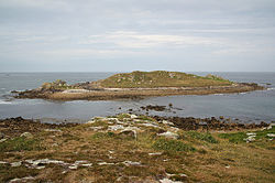
 Gweal seen from Bryher | |
|---|---|
| Location | |
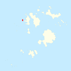
| Grid reference: | SV867152 |
| Area: | 14½ acres |
| Highest point: | 105 feet |
| Data | |
Gweal is one of the uninhabited islands of the Isles of Scilly, Cornwall. It is the largest of the seven Norrard Rocks due west of Bryher.
The island's name is from the Cornish Gwithial, meaning place of trees, a name which perhaps refers back to a time before most of the islands' area was inundated.
References
- Weatherhill, Craig Cornish Placenames and Language
| Isles of Scilly |
|---|
|
St Mary's •
St Agnes •
Tresco •
Bryher •
St Martin's •
Gugh
|
