Birker Force: Difference between revisions
Jump to navigation
Jump to search
categorised |
m Fixed infobox typo |
||
| Line 1: | Line 1: | ||
{{Infobox waterfall | {{Infobox waterfall | ||
|name=Birker Force | |name=Birker Force | ||
|county | |county=Cumberland | ||
|picture=Birker Force - geograph.org.uk - 1142068.jpg | |picture=Birker Force - geograph.org.uk - 1142068.jpg | ||
|picture caption=Birker Force emerging from the crags | |picture caption=Birker Force emerging from the crags | ||
| Line 19: | Line 19: | ||
{{reflist}} | {{reflist}} | ||
*Martineau, Harriet: 'A Complete Guide to the English Lakes' (John Garnett / Whittaker and Co,, 1855-71), page 180 | *Martineau, Harriet: 'A Complete Guide to the English Lakes' (John Garnett / Whittaker and Co,, 1855-71), page 180 | ||
Latest revision as of 19:08, 9 October 2019
| Birker Force | |
| Cumberland | |
|---|---|
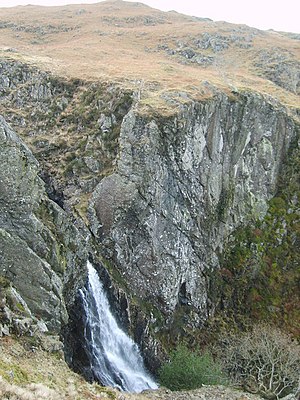
 Birker Force emerging from the crags | |
| River: | Low Birker Pool |
| Fall: | 328 feet |
| SD18759993 | |
| Co-ordinates: | 54°23’18"N, 3°15’9"W |
Birker Force is a waterfall on a stream known as the Low Birker Pool which runs from the slopes of Birker Fell in Cumberland, within south-western fells of the Lake District.
Here the beck, running down the northern slopes of the fell, in the dip before Harter Fell to the east, tumbles over the crags of the fell in a beauteous cascade 328 feet down into Eskdale, where soon the Low Birker Pool enters the River Esk.
This is reckoned one of the finest waterfalls for spectacle in the Lake District, and is frequently visited along with its neighbour, the Stanley Ghyll Force over which Birker Beck falls into the dale.
References
- Martineau, Harriet: 'A Complete Guide to the English Lakes' (John Garnett / Whittaker and Co,, 1855-71), page 180