Lovington: Difference between revisions
m →Parish church: ioe -> nhle, replaced: {{IoE|263380 → {{NHLE|1056528, {{IoE|430605 → {{NHLE|1248850 |
|||
| (One intermediate revision by one other user not shown) | |||
| Line 25: | Line 25: | ||
==Parish church== | ==Parish church== | ||
The parish church is the Church of St Thomas of Canterbury. It has 13th-century origins and was restored and enlarged in 1861. The church has been designated a Grade II* listed building.<ref>{{ | The parish church is the Church of St Thomas of Canterbury. It has 13th-century origins and was restored and enlarged in 1861. The church has been designated a Grade II* listed building.<ref>{{NHLE|1056528|Church of St Thomas of Canterbury}}</ref> | ||
The Church of St John Baptist was converted into a private house in the 1970s.<ref>{{ | The Church of St John Baptist was converted into a private house in the 1970s.<ref>{{NHLE|1248850|Church of St John Baptist}}</ref> | ||
In the 1780s Thomas Charles held the curacy of Lovington along with several other local parishes. | In the 1780s Thomas Charles held the curacy of Lovington along with several other local parishes. | ||
| Line 35: | Line 35: | ||
==References== | ==References== | ||
{{reflist|colwidth=30em}} | {{reflist|colwidth=30em}} | ||
Latest revision as of 08:26, 19 September 2019
| Lovington | |
| Somerset | |
|---|---|
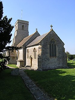
 Church of St Thomas of Canterbury, Lovington | |
| Location | |
| Grid reference: | ST595305 |
| Location: | 51°4’20"N, 2°34’46"W |
| Data | |
| Population: | 141 (2011[1]) |
| Post town: | Castle Cary |
| Postcode: | BA7 |
| Dialling code: | 01963 |
| Local Government | |
| Council: | South Somerset |
| Parliamentary constituency: |
Somerton and Frome |
Lovington is a village and parish in Somerset, situated three miles south-west of Castle Cary, between the River Brue and River Cary. The civil parish, which includes the ancient parish of Wheathill, has a population of 141.[1] Lovington forms part of the hundred of Catsash, while Wheathill forms a detached part of the Whitley Hundred.[2]
History
The name of the village comes from Old English meaning Lufa's settlement.[3]
There was a mill on the River Brue in the village at the time of the Domesday Book, when it was held by Serlo de Burci,[3] however it is not certain whether this is the same site as the current Lovington Mill which was built around 1800.[4]
The village school was built in the early 19th century,[5] and was helped later in the century, with donations and equipment, by the local priest and hymn writer Godfrey Thring.
Parish church
The parish church is the Church of St Thomas of Canterbury. It has 13th-century origins and was restored and enlarged in 1861. The church has been designated a Grade II* listed building.[6]
The Church of St John Baptist was converted into a private house in the 1970s.[7]
In the 1780s Thomas Charles held the curacy of Lovington along with several other local parishes.
Outside links
| ("Wikimedia Commons" has material about Lovington) |
References
- ↑ 1.0 1.1 "Statistics for Wards, LSOAs and Parishes — SUMMARY Profiles" (Excel). Somerset Intelligence. http://www.somersetintelligence.org.uk/files/Somerset%20Census%20Key%20Statistics%20-%20Summary%20Profiles.xls. Retrieved 4 January 2014.
- ↑ "Somerset Hundreds". GENUKI. http://www.genuki.org.uk/big/eng/SOM/Miscellaneous/. Retrieved 22 October 2011.
- ↑ 3.0 3.1 Bush, Robin (1994). Somerset: The complete guide. Wimborne: The Dovecote Press Ltd. pp. 133. ISBN 1-874336-26-1.
- ↑ "Lovington Mill House and the Mill attached". Images of England. English Heritage. http://www.imagesofengland.org.uk/Details/Default.aspx?id=263374. Retrieved 24 January 2009.
- ↑ "Lovington School with adjoining School House". Images of England. English Heritage. http://www.imagesofengland.org.uk/Details/Default.aspx?id=263371. Retrieved 24 January 2009.
- ↑ National Heritage List 1056528: Church of St Thomas of Canterbury
- ↑ National Heritage List 1248850: Church of St John Baptist
