Saltford Lock: Difference between revisions
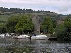
Created page with "{{county|Somerset}} thumb|250px|Kelston Brass Mill overlooking Saltford lock '''Saltford Lock''' is a canal lock situated on the River Avon, So..." |
|||
| Line 17: | Line 17: | ||
[[Category:Locks on the Kennet and Avon Canal]] | [[Category:Locks on the Kennet and Avon Canal]] | ||
[[Category: | [[Category:Locks in Somerset]] | ||
Latest revision as of 12:29, 27 June 2019

Saltford Lock is a canal lock situated on the River Avon, at the village of Saltford, Somerset, between Bristol and Bath.
The Bristol Avon Navigation, which runs the 15 miles from the Kennet and Avon Canal at Hanham Lock to the Bristol Channel at Avonmouth, was constructed between 1724 and 1727,[1] following legislation passed by Queen Anne,[2][3] by a company of proprietors and the engineer John Hore of Newbury, Berkshire. The first cargo of 'Deal boards, Pig-Lead and Meal' arrived in Bath in December 1727.[4] The navigation is now administered by the Canal & River Trust.
The lock and weir are overlooked by the remains of the Kelston Brass Mill, which was working until 1925. It is a Grade-II listed building.[5] Alongside the lock is the Jolly Sailor pub, whose garden extends over the lock to the small island between the lock and weir. The lock was opened in 1727 and destroyed in 1738 (probably by rival coal dealers) to stop the use of the river for transportation.[6][7] The pub was built in 1726 for the bargees, when the navigation opened. The wooden fireplace has holes made by hot pokers by newly promoted barge captains.[8][9]
References
- ↑ "Bristol Avon Navigation". Inland Waterways Association. https://www.waterways.org.uk/waterways/canals_rivers/bristol_avon/bristol_avon. Retrieved 3 March 2013.
- ↑ "Navigation of the river Avon". Bristol History.com. Archived from the original on 10 January 2007. https://web.archive.org/web/20070110214011/http://weldgen.tripod.com/bristol-history-com/id2.html. Retrieved 22 September 2006.
- ↑ Priestley, Joseph (1831). "
 Avon River, Gloucestershire". Historical Account of the Navigable Rivers, Canals, and Railways, of Great Britain. Longman, Rees, Orme, Brown & Green. Wikisource.
- ↑ Allsop, Niall (1989). The Kennet & Avon Canal (2 ed.). Millstream Books. p. 4. ISBN 9780948975158.
- ↑ "Remains of 2 Annealing Ovens". Images of England. http://www.imagesofengland.org.uk/details/default.aspx?id=399986. Retrieved 2006-09-24.
- ↑ Allsop, Niall (1989). The Kennet & Avon Canal (2 ed.). Millstream Books. p. 17. ISBN 9780948975158.
- ↑ Wood, John (1749). An Essay Towards a Description of Bath. Bath: James Bettenham.
- ↑ "The Jolly Sailor Inn". Historic England. https://www.historicengland.org.uk/listing/the-list/list-entry/1384668. Retrieved 25 September 2016.
- ↑ Clew, Kenneth R. (1978). Wessex Waterway. Moonraker Press. p. 59. ISBN 978-0239001818.
See also
Outside links
- Location map: 51°24’35"N, 2°26’35"W