Cullyhanna: Difference between revisions
Created page with '{{Infobox town |name=Cullyhanna |county=Armagh |picture= |picture caption= |os grid ref=H9221 |LG district=Newry & Mourne }} '''Cullyhanna''' is a village in County Armagh. …' |
No edit summary |
||
| Line 2: | Line 2: | ||
|name=Cullyhanna | |name=Cullyhanna | ||
|county=Armagh | |county=Armagh | ||
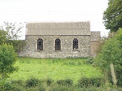
|picture= | |picture=A disused church - geograph.org.uk - 547180.jpg | ||
|picture caption= | |picture caption=Former church at Cullyhanna | ||
|os grid ref= | |os grid ref=H923210 | ||
|LG district=Newry | |latitude=54.12999 | ||
|longitude=-6.5884399 | |||
|population= | |||
|census year= | |||
|post town= | |||
|postcode= | |||
|dialling code= | |||
|LG district=Newry, Mourne and Down | |||
|constituency= | |||
|townland=yes | |||
}} | }} | ||
'''Cullyhanna''' is a village in [[County Armagh]]. | '''Cullyhanna''' is a small village and [[townland]] in [[County Armagh]]. It stands on the main road between [[Newtownhamilton]] and [[Crossmaglen]], and had a population of 306 in the 2001 census. | ||
The place-name is from the Irish language; either from ''Coilleach Eanach'', meaning 'Marshy wood', or ''Coill Uí hAnnaidh'', meaning 'Ó Hanna's wood'. | |||
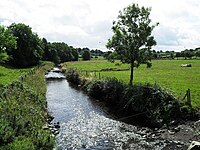
The border runs north to south a little to the west of the village, on a river known as the County Water, which is bridged by the County Bridge: to the west is [[County Monaghan]] in the [[Republic of Ireland]]. | |||
==History in the Troubles== | |||
Cullyhanna is in South Armagh, a region that during the Troubles was a stronghold of support for the IRA, earning it the nickname "Bandit Country". The British Army nicknamed the local IRA unit the "Cullyhanna Gun Club". The village and the surrounding townland were the most dangerous areas in Northern Ireland for security forces during the mid 1990s, until the second IRA ceasefire. | |||
[[File:The Border at the County Bridge, Cullyhanna - geograph.org.uk - 1446879.jpg|right|thumb|200px|The Border, on the County Water]] | |||
==Sport== | |||
*Gaelic games: St Patrick's GFC, Cullyhanna, which has men's and women's Gaelic football teams and camogie. | |||
*Golf: Ashfield Golf Course is an 18-hole course at Cullyhanna | |||
==Outside links== | |||
*[http://www.cregganhistory.co.uk/CHCintroduction.htm St Patrick's Cemetery, Cullyhanna] | |||
*[http://www.ofiaichcentre.co.uk/ Cardinal Ó Fíaich Heritage Centre] | |||
==References== | |||
*[http://www.nisra.gov.uk/ninis/ NI Neighbourhood Information Service] | |||
Latest revision as of 17:15, 23 May 2019
| Cullyhanna | |
| County Armagh | |
|---|---|
 Former church at Cullyhanna | |
| Location | |
| Grid reference: | H923210 |
| Location: | 54°7’48"N, 6°35’18"W |
| Data | |
| Local Government | |
| Council: | Newry, Mourne and Down |
Cullyhanna is a small village and townland in County Armagh. It stands on the main road between Newtownhamilton and Crossmaglen, and had a population of 306 in the 2001 census.
The place-name is from the Irish language; either from Coilleach Eanach, meaning 'Marshy wood', or Coill Uí hAnnaidh, meaning 'Ó Hanna's wood'.
The border runs north to south a little to the west of the village, on a river known as the County Water, which is bridged by the County Bridge: to the west is County Monaghan in the Republic of Ireland.
History in the Troubles
Cullyhanna is in South Armagh, a region that during the Troubles was a stronghold of support for the IRA, earning it the nickname "Bandit Country". The British Army nicknamed the local IRA unit the "Cullyhanna Gun Club". The village and the surrounding townland were the most dangerous areas in Northern Ireland for security forces during the mid 1990s, until the second IRA ceasefire.

Sport
- Gaelic games: St Patrick's GFC, Cullyhanna, which has men's and women's Gaelic football teams and camogie.
- Golf: Ashfield Golf Course is an 18-hole course at Cullyhanna