Difference between revisions of "Lyell Glacier"
(Created page with 'Thatcher Peninsula on Cumberland Bay '''Lyell Glacier''' ({{lat & long|-54.2833|-36.61667}}) is a glacier flowing in a northward…') |
|||
| Line 1: | Line 1: | ||
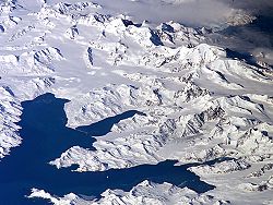
| − | [[File:Thatcher-Peninsula.jpg|right|thumb| | + | [[File:Thatcher-Peninsula.jpg|right|thumb|250px|Thatcher Peninsula on Cumberland Bay]] |
| − | '''Lyell Glacier''' | + | '''Lyell Glacier''' is a glacier flowing in a northward direction to [[Harpon Bay]] at the southeast head of [[Cumberland West Bay]], [[South Georgia]]. It was mapped by the Swedish Antarctic Expedition, 1901–04, under Nordenskjöld, who named it for Sir Charles Lyell (1797–1875), eminent British geologist. |
While the British Magistrate and other civilians and military present in [[Grytviken]] were removed from South Georgia, another 15 Britons remained beyond Argentine reach. The losses suffered at Grytviken prevented Argentina from occupying the rest of the island, with [[Bird Island, South Georgia|Bird Island]] base, and field camps at [[Schlieper Bay]], Lyell Glacier and [[St Andrews Bay, South Georgia|St Andrews Bay]] remaining under British control. | While the British Magistrate and other civilians and military present in [[Grytviken]] were removed from South Georgia, another 15 Britons remained beyond Argentine reach. The losses suffered at Grytviken prevented Argentina from occupying the rest of the island, with [[Bird Island, South Georgia|Bird Island]] base, and field camps at [[Schlieper Bay]], Lyell Glacier and [[St Andrews Bay, South Georgia|St Andrews Bay]] remaining under British control. | ||
| + | |||
| + | ==Location== | ||
| + | *Location: {{wmap|-54.3223|-36.6245}} | ||
| + | |||
| + | ==References== | ||
| + | {{reflist}} | ||
| + | *{{basgaz}} | ||
| + | |||
| + | {{Glaciers of South Georgia}} | ||
[[Category:Glaciers of South Georgia]] | [[Category:Glaciers of South Georgia]] | ||
Latest revision as of 20:13, 5 April 2019
Lyell Glacier is a glacier flowing in a northward direction to Harpon Bay at the southeast head of Cumberland West Bay, South Georgia. It was mapped by the Swedish Antarctic Expedition, 1901–04, under Nordenskjöld, who named it for Sir Charles Lyell (1797–1875), eminent British geologist.
While the British Magistrate and other civilians and military present in Grytviken were removed from South Georgia, another 15 Britons remained beyond Argentine reach. The losses suffered at Grytviken prevented Argentina from occupying the rest of the island, with Bird Island base, and field camps at Schlieper Bay, Lyell Glacier and St Andrews Bay remaining under British control.
Location
- Location: 54°19’20"S, 36°37’28"W
References
- Gazetteer and Map of the BAT and SGSSI: Lyell Glacier
| Glaciers of South Georgia |
|---|
|
Austin • Bary • Bertrab • Bogen • Briggs • Brøgger • Brunonia • Buxton • Christensen • Christophersen • Clayton • Cook • Crean • Dead End • Eclipse • Esmark • Fortuna • Geikie • Graae • Grace • Hamberg • Harker • Harmer • Heaney • Helland • Henningsen • Herz • Hindle • Hodges • Jenkins • Jewell • Keilhau • Kjerulf • König • Lancing • Lewald • Lucas • Lyell • Morris • Nachtigal • Neumayer • Nordenskjöld • Novosilski • Paget • Peters • Philippi • Price • Purvis • Quensel • Risting • Ross • Ryan • Salomon • Schrader • Spenceley • Storey • Twitcher • Tyrrell • Webb • Weddell • Wheeler |
