Coupar Angus: Difference between revisions
m clean up, typos fixed: aroud → around |
No edit summary |
||
| (One intermediate revision by the same user not shown) | |||
| Line 15: | Line 15: | ||
|constituency=Perth and North Perthshire | |constituency=Perth and North Perthshire | ||
}} | }} | ||
'''Coupar Angus''' is a small town in [[Perthshire]], hard by the border of [[Angus]], | '''Coupar Angus''' is a small town in [[Perthshire]], hard by the border of [[Angus]], five miles south of [[Blairgowrie]]. The town lies mostly within Perthshire, but the county border cuts through the outer edge of town, marked by the Coupar Burn. The [[Coupar Angus Abbey|Abbey]] in whose shadow the town grew up in the Middle Ages stood on the opposite bank of the burn. | ||
It is a small town at the centre of the rich agriculturally heartland of [[Strathmore, Perthshire|Strathmore]], on the southern side of the [[River Isla]], found some 14 miles north east of Perth and 12 miles north west of Dundee. Appropriately for a town divided between Perthshire and Forfarshire, Coupar Angus is on the A94 [[Perth]] to [[Forfar]] road, although the town centre itself is now bypassed. | It is a small town at the centre of the rich agriculturally heartland of [[Strathmore, Perthshire|Strathmore]], on the southern side of the [[River Isla]], found some 14 miles north-east of Perth and 12 miles north-west of Dundee. Appropriately for a town divided between Perthshire and Forfarshire, Coupar Angus is on the A94 [[Perth]] to [[Forfar]] road, although the town centre itself is now bypassed. | ||
The town was known as the "Queen of Strathmore" at the height of its prosperity, which is yet reflected in the fine architecture in the town. | The town was known as the "Queen of Strathmore" at the height of its prosperity, which is yet reflected in the fine architecture in the town. | ||
| Line 38: | Line 38: | ||
===Coupar Angus Abbey=== | ===Coupar Angus Abbey=== | ||
[[File:Coupar Angus Abbey.jpg|right|thumb|170px|Abbey remains]] | [[File:Coupar Angus Abbey.jpg|right|thumb|170px|Abbey remains]] | ||
In about 1160, King Malcolm IV (1153–65) sealed a charter for the foundation of a Cistercian abbey, which may have been on the advice of his uncle, Waltheof, Abbot of [[Melrose]], another Cistercian house. Coupar Angus Abbey was in time to equal Melrose and become one of Scotland's most important monasteries. | In about 1160, King Malcolm IV (1153–65) sealed a charter for the foundation of a Cistercian abbey, which may have been on the advice of his uncle, Waltheof, Abbot of [[Melrose]], another Cistercian house. Coupar Angus Abbey was in time to equal [[Melrose Abbey|Melrose]] and become one of Scotland's most important monasteries. | ||
The abbey in its formal layout was built in 1233, but today only architectural fragments remain, preserved in the 19th century parish church (which is probably on the site of the monastic church), or built into houses and walls throughout the town, survive, along with part of one of its gatehouses. Over the Middle Ages, gifts of further land were made to the Abbey and by the early 14th century the Abbey owned 8,000 acres until at the time of the Reformation, Coupar Angus was said to be the wealthiest Cistercian Abbey in Scotland. | The abbey in its formal layout was built in 1233, but today only architectural fragments remain, preserved in the 19th century parish church (which is probably on the site of the monastic church), or built into houses and walls throughout the town, survive, along with part of one of its gatehouses. Over the Middle Ages, gifts of further land were made to the Abbey and by the early 14th century the Abbey owned 8,000 acres until at the time of the Reformation, Coupar Angus was said to be the wealthiest Cistercian Abbey in Scotland. | ||
In 1559 at the Reformation the Abbey buildings were partially destroyed. The Abbey was only formally dissolved in 1607 by King James VI. Little remains today, the stone born away to build the town anew, though a small wall fragment and gateway arch stand to bear witness to the wealth | In 1559 at the Reformation the Abbey buildings were partially destroyed. The Abbey was only formally dissolved in 1607 by King James VI. Little remains today, the stone born away to build the town anew, though a small wall fragment and gateway arch stand to bear witness to the wealth concentrated in the hands of those sworn to lives of poverty. | ||
===Growth of the town=== | ===Growth of the town=== | ||
The mediæval village clustered by the banks of the Coupar Burn and in those early days a market was held every Friday at the Market Cross. The market cross was a focus, marking the centre of the Burgh of Barony. Coupar Angus seems indeed to have become a significant market town, standing where the roads from [[Perth]], [[Dundee]] and the [[Highlands]] met at a crossing point across the River Isla. | The mediæval village clustered by the banks of the Coupar Burn and in those early days a market was held every Friday at the Market Cross. The market cross was a focus, marking the centre of the Burgh of Barony. Coupar Angus seems indeed to have become a significant market town, standing where the roads from [[Perth]], [[Dundee]] and the [[Highlands]] met at a crossing point across the River Isla. | ||
In the 17th century with the Abbey gone the town did not fade away but prospered and grew. Trades flourished and new churches were built and new cobbled streets ("'causeys'") were laid. After the Union in the Georgian period the town grew further from its position on the roads into the Highlands. The Royal Hotel and the White Horse Inn are Georgian coaching inns serving travellers and in particular the daily stage-coaches which ran through Coupar Angus from Perth to Aberdeen. | In the 17th century, with the Abbey gone, the town did not fade away but prospered and grew. Trades flourished and new churches were built and new cobbled streets ("'causeys'") were laid. After the Union in the Georgian period the town grew further from its position on the roads into the Highlands. The Royal Hotel and the White Horse Inn are Georgian coaching inns serving travellers and in particular the daily stage-coaches which ran through Coupar Angus from Perth to Aberdeen. | ||
Apart from trade, the Army appreciated its position and the Cumberland Barracks were built, seeing service in the suppression of the 1745 Jacobite Rising, which was the last of war and made an end of centuries of clan warfare in the high glens. | Apart from trade, the Army appreciated its position and the Cumberland Barracks were built, seeing service in the suppression of the 1745 Jacobite Rising, which was the last of war and made an end of centuries of clan warfare in the high glens. | ||
| Line 56: | Line 56: | ||
[[File:Town Hall, Coupar Angus - geograph.org.uk - 411905.jpg|right|thumb|200px|Town Hall]] | [[File:Town Hall, Coupar Angus - geograph.org.uk - 411905.jpg|right|thumb|200px|Town Hall]] | ||
The railway came in 1837, slicing straight across the top of the High Street, where level crossing gates operated. The railway though brought trade, visitors and new residents, new houses spreading up the Blairgowrie Road. The town blossomed and the High Street filled with local shops, while around it were new mills: saw mills, a tannery, bakehouses, a brewery and a print factory amongst others opened. A jam factory became one of the biggest businesses in town, and continued until the 1960s. | The railway came in 1837, slicing straight across the top of the High Street, where level crossing gates operated. The railway though brought trade, visitors and new residents, new houses spreading up the Blairgowrie Road. The town blossomed and the High Street filled with local shops, while around it were new mills: saw mills, a tannery, bakehouses, a brewery and a print factory amongst others opened. A jam factory became one of the biggest businesses in town, and continued until the 1960s. | ||
In 1859, the parish church, restored in the previous century, was pulled down and replaced by the present parish church in 1859, to the design of local architect John Carver. Other churches opened to though of other denominations, and a new school in 1886-87. In 1887, a Town Hall was built to celebrate Queen Victoria's diamond jubilee. | In 1859, the parish church, restored in the previous century, was pulled down and replaced by the present parish church in 1859, to the design of local architect John Carver. Other churches opened to though of other denominations, and a new school in 1886-87. In 1887, a Town Hall was built to celebrate Queen Victoria's diamond jubilee. | ||
Latest revision as of 15:08, 15 November 2018
| Coupar Angus | |
| Perthshire | |
|---|---|
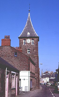
 Clock Tower | |
| Location | |
| Grid reference: | NO222401 |
| Location: | 56°32’47"N, 3°16’1"W |
| Data | |
| Population: | 1,755 (2001) |
| Post town: | Blairgowrie |
| Postcode: | PH13 |
| Dialling code: | 01828 |
| Local Government | |
| Council: | Perth and Kinross |
| Parliamentary constituency: |
Perth and North Perthshire |
Coupar Angus is a small town in Perthshire, hard by the border of Angus, five miles south of Blairgowrie. The town lies mostly within Perthshire, but the county border cuts through the outer edge of town, marked by the Coupar Burn. The Abbey in whose shadow the town grew up in the Middle Ages stood on the opposite bank of the burn.
It is a small town at the centre of the rich agriculturally heartland of Strathmore, on the southern side of the River Isla, found some 14 miles north-east of Perth and 12 miles north-west of Dundee. Appropriately for a town divided between Perthshire and Forfarshire, Coupar Angus is on the A94 Perth to Forfar road, although the town centre itself is now bypassed.
The town was known as the "Queen of Strathmore" at the height of its prosperity, which is yet reflected in the fine architecture in the town.
Though in the midst of the famers of Strathmore, it is close to the Highlands: the Grampian Mountains are a short drive to the north; while to the south lie the Sidlaw Hills.
Name of the town
The name "Coupar Angus" is taken from the early days of the town which grew up around the Abbey, which stood across the Coupar Burn in the County of Angus. Today's town though is firmly on the Perthshire bank, albeit its outer accretions spreading across the county border. The full name serves also to differentiate the town from Cupar in Fife.
The name "Coupar" is from an old Gaelic word for "confluence" (Comar in modern Gaelic), marking where the Coupar Burn meets the Isla.
In Herman Moll's Map of the 18th century, the town is called simply Couper.[1] John Thomson's Atlas of Scotland of 1832 calls it both Couparancus.[2] and Coupar Angus.[3]
History
Early days
Bronze Age burial cists show the hand of man and remains have been found of Iron Age farms exploiting the richness of Strathmore. Though far off the marching routes, the Romans were here; a temporary Roman camp has been unearthed at Lintrose to the south of Coupar Angus.
The foundation of the village of Couper is uncertain, but there was a royal manor here in the early 12th century, in the reign of King David I (1124-1153).
Coupar Angus Abbey

In about 1160, King Malcolm IV (1153–65) sealed a charter for the foundation of a Cistercian abbey, which may have been on the advice of his uncle, Waltheof, Abbot of Melrose, another Cistercian house. Coupar Angus Abbey was in time to equal Melrose and become one of Scotland's most important monasteries.
The abbey in its formal layout was built in 1233, but today only architectural fragments remain, preserved in the 19th century parish church (which is probably on the site of the monastic church), or built into houses and walls throughout the town, survive, along with part of one of its gatehouses. Over the Middle Ages, gifts of further land were made to the Abbey and by the early 14th century the Abbey owned 8,000 acres until at the time of the Reformation, Coupar Angus was said to be the wealthiest Cistercian Abbey in Scotland.
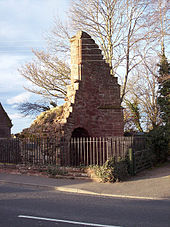
In 1559 at the Reformation the Abbey buildings were partially destroyed. The Abbey was only formally dissolved in 1607 by King James VI. Little remains today, the stone born away to build the town anew, though a small wall fragment and gateway arch stand to bear witness to the wealth concentrated in the hands of those sworn to lives of poverty.
Growth of the town
The mediæval village clustered by the banks of the Coupar Burn and in those early days a market was held every Friday at the Market Cross. The market cross was a focus, marking the centre of the Burgh of Barony. Coupar Angus seems indeed to have become a significant market town, standing where the roads from Perth, Dundee and the Highlands met at a crossing point across the River Isla.
In the 17th century, with the Abbey gone, the town did not fade away but prospered and grew. Trades flourished and new churches were built and new cobbled streets ("'causeys'") were laid. After the Union in the Georgian period the town grew further from its position on the roads into the Highlands. The Royal Hotel and the White Horse Inn are Georgian coaching inns serving travellers and in particular the daily stage-coaches which ran through Coupar Angus from Perth to Aberdeen.
Apart from trade, the Army appreciated its position and the Cumberland Barracks were built, seeing service in the suppression of the 1745 Jacobite Rising, which was the last of war and made an end of centuries of clan warfare in the high glens.
In 1762 public subscription paid for the building of the Steeple, completed in 1769. The Steeple was the town tolbooth and provided a meeting house for local courts on the upper floors, with a gaol on the ground floor. In 1766 a bridge was at last built across the Isla, the Couttie Bridge.
Victorian period

The railway came in 1837, slicing straight across the top of the High Street, where level crossing gates operated. The railway though brought trade, visitors and new residents, new houses spreading up the Blairgowrie Road. The town blossomed and the High Street filled with local shops, while around it were new mills: saw mills, a tannery, bakehouses, a brewery and a print factory amongst others opened. A jam factory became one of the biggest businesses in town, and continued until the 1960s.
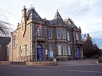
In 1859, the parish church, restored in the previous century, was pulled down and replaced by the present parish church in 1859, to the design of local architect John Carver. Other churches opened to though of other denominations, and a new school in 1886-87. In 1887, a Town Hall was built to celebrate Queen Victoria's diamond jubilee.
By the opening of the twentieth century, weekly grain markets were being held on Thursdays, drawing farmers to the town, and cattle fairs in September and October. The annual horse fair was held in March, which still continues today, though in a somewhat different format.
The town today
During the 20th century the linen trade declined and mills began to close, but industry remains. Fruit picking feeds supermarkets in a wide area and food processing plants in town.
Events
- The Horse Fair
Sport
Coupar Angus is home to:
- Coupar Angus FC, a junior football club
- Coupar Angus Amateur Football Club
Outside links
- Coupar Angus village website
References
- ↑ The South Part of the Shire of Perth by H Moll – National Library of Scotland
- ↑ National Library of Scotland – John Thomson Atlas of Scotland: Forfarshire, south sheet
- ↑ National Library of Scotland – John Thomson Atlas of Scotland: Perthshire, north-east sheet