Hawkesdown Hill: Difference between revisions
Jump to navigation
Jump to search
Created page with "{{Infobox hill |name=Hawkesdown Hill |county=Devon |range= |picture=Hawkesdown Hill and Axmouth - geograph.org.uk - 815858.jpg |picture caption=Hawkesdown Hill and Axmouth |os..." |
No edit summary |
||
| Line 11: | Line 11: | ||
|height_m= | |height_m= | ||
}} | }} | ||
'''Hawkesdown Hill''' is a prominent hill in the very east of [[Devon]], immediately to the north of [[Axmouth]] and overlooking the estuary of the [[River Axe]], to the west. On its summit is an Iron Age hill fort. | '''Hawkesdown Hill''' is a prominent hill in the very east of [[Devon]], immediately to the north of [[Axmouth]] and overlooking the estuary of the [[River Axe, Devon|River Axe]], to the west. On its summit is an Iron Age hill fort. | ||
The fort is approximately 427 feet above sea level, with a commanding view over the estuary notwithstanding its modest height, the northern, western and southern slopes being precipitous down to the river and the village. | The fort is approximately 427 feet above sea level, with a commanding view over the estuary notwithstanding its modest height, the northern, western and southern slopes being precipitous down to the river and the village. | ||
Latest revision as of 10:08, 27 October 2018
| Hawkesdown Hill | |
| Devon | |
|---|---|
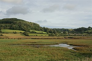
 Hawkesdown Hill and Axmouth | |
| 50°43’5"N, 3°2’38"W | |
Hawkesdown Hill is a prominent hill in the very east of Devon, immediately to the north of Axmouth and overlooking the estuary of the River Axe, to the west. On its summit is an Iron Age hill fort.
The fort is approximately 427 feet above sea level, with a commanding view over the estuary notwithstanding its modest height, the northern, western and southern slopes being precipitous down to the river and the village.
References
- Sellman, R.R.: 'Aspects of Devon History' (Devon Books, 1985) ISBN 0-86114-756-1. Chapter: "The Iron Age in Devon" (Map of Iron Age hill forts in Devon)