Rumney: Difference between revisions
Created page with '{{Infobox town |name=Rumney |welsh=Tredelerch |county=Monmouthshire |picture=Rumney Library Cardiff.JPG |picture caption=Rumney Library |os grid ref=ST215795 |latitude=51.50895 …' |
No edit summary |
||
| (One intermediate revision by one other user not shown) | |||
| Line 3: | Line 3: | ||
|welsh=Tredelerch | |welsh=Tredelerch | ||
|county=Monmouthshire | |county=Monmouthshire | ||
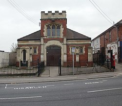
|picture=Rumney | |picture=Rumney War Memorial Hall, Cardiff - geograph.org.uk - 1805209.jpg | ||
|picture caption=Rumney | |picture caption=Rumney War Memorial Hall | ||
|os grid ref=ST215795 | |os grid ref=ST215795 | ||
|latitude=51.50895 | |latitude=51.50895 | ||
| Line 16: | Line 16: | ||
|constituency=Cardiff South & Penarth | |constituency=Cardiff South & Penarth | ||
}} | }} | ||
'''Rumney''' is a town of [[Monmouthshire]] which has become an eastern suburb of [[Cardiff]]. It lies on the east bank of the [[River | '''Rumney''' is a town of [[Monmouthshire]] which has become an eastern suburb of [[Cardiff]]. It lies on the east bank of the [[Rhymney River]], from which it takes its name. | ||
Rumney stands at the mouth of the River Rhymney, while at the source of the river is a village bearing the Welsh spelling of the name; [[Rhymney]]. [[Llanrumney]] stands nearby too. | Rumney stands at the mouth of the River Rhymney, while at the source of the river is a village bearing the Welsh spelling of the name; [[Rhymney]]. [[Llanrumney]] stands nearby too. | ||
| Line 23: | Line 23: | ||
Within the older sectors of the Rumney area are places of interest, such as the historic Rumney Pottery which is still in use today and also the remains of the old Rumney Castle which was a major stronghold on the [[South Wales]] coast. The remains of the castle were excavated in the late 70s and early 80s. An old quarry which is now being used as a children's park is situated off Ty Mawr Road. | Within the older sectors of the Rumney area are places of interest, such as the historic Rumney Pottery which is still in use today and also the remains of the old Rumney Castle which was a major stronghold on the [[South Wales]] coast. The remains of the castle were excavated in the late 70s and early 80s. An old quarry which is now being used as a children's park is situated off Ty Mawr Road. | ||
In the very south-west of the parish, a loop in the Rhymney River forms the southernmost point of Monmouthshire. | |||
==Outside links== | ==Outside links== | ||
| Line 31: | Line 33: | ||
[[Category:Cardiff]] | [[Category:Cardiff]] | ||
[[Category:Extreme points of Monmouthshire]] | |||
Latest revision as of 21:38, 2 May 2018
| Rumney Welsh: Tredelerch | |
| Monmouthshire | |
|---|---|
 Rumney War Memorial Hall | |
| Location | |
| Grid reference: | ST215795 |
| Location: | 51°30’32"N, 3°7’57"W |
| Data | |
| Population: | 8,964 (2001) |
| Post town: | Cardiff |
| Postcode: | CF3 |
| Dialling code: | 029 |
| Local Government | |
| Council: | Cardiff |
| Parliamentary constituency: |
Cardiff South & Penarth |
Rumney is a town of Monmouthshire which has become an eastern suburb of Cardiff. It lies on the east bank of the Rhymney River, from which it takes its name.
Rumney stands at the mouth of the River Rhymney, while at the source of the river is a village bearing the Welsh spelling of the name; Rhymney. Llanrumney stands nearby too.
This is a predominately residential area with a variety of social and private housing. There are many shopping outlets on Newport Road as well as local shops at the top of Rumney Hill and on Wentloog Road, Countisbury Avenue in Llanrumney also. New Industrial & Business Estates have been developed alongside existing ones on Lamby Way providing welcome employment opportunities for many residents in Cardiff.
Within the older sectors of the Rumney area are places of interest, such as the historic Rumney Pottery which is still in use today and also the remains of the old Rumney Castle which was a major stronghold on the South Wales coast. The remains of the castle were excavated in the late 70s and early 80s. An old quarry which is now being used as a children's park is situated off Ty Mawr Road.
In the very south-west of the parish, a loop in the Rhymney River forms the southernmost point of Monmouthshire.
Outside links
- Pictures on Geograph.co.uk
- [1]: The local Scout Group for Rumney and Llanrumney

This Monmouthshire article is a stub: help to improve Wikishire by building it up.