Normanby Top: Difference between revisions
Jump to navigation
Jump to search
No edit summary |
No edit summary |
||
| Line 8: | Line 8: | ||
|location=Lincolnshire Wolds | |location=Lincolnshire Wolds | ||
|os grid ref=TF121964 | |os grid ref=TF121964 | ||
|latitude=53.452442 | |||
|longitude=-0.313365 | |||
}} | }} | ||
'''Normanby Top''' or '''Wolds Top''' are names given to the highest point of the [[Lincolnshire Wolds]], which also marks the [[county top]] of [[Lincolnshire]]. | '''Normanby Top''' or '''Wolds Top''' are names given to the highest point of the [[Lincolnshire Wolds]], which also marks the [[county top]] of [[Lincolnshire]]. | ||
Latest revision as of 09:17, 22 March 2018
| Normanby Top | |||
| Lincolnshire | |||
|---|---|---|---|
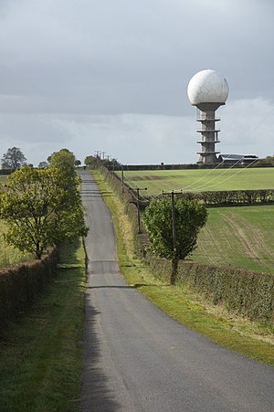
 The National Air Traffic Control Radar Installation(Claxby) | |||
| Range: | Lincolnshire Wolds | ||
| Summit: | 531 feet TF121964 53°27’9"N, 0°18’48"W | ||
Normanby Top or Wolds Top are names given to the highest point of the Lincolnshire Wolds, which also marks the county top of Lincolnshire.
Normanby Top is in Lindsey, a mile or so north of the village of Normanby-le-Wold. The Viking Way passes close by, on a minor road, and there is a radio mast near the summit. The summit is marked with an Ordnance Survey triangulation station, which was erected in July 1999 as part of the Ordnance Survey national GPS system.
