Bald Hill: Difference between revisions
Created page with '{{infobox hill |name=Bald Hill |county=Oxfordshire |picture= Bald Hill - geograph.org.uk - 1416878.jpg |picture caption=Bald Hill from the Ridgeway path |height=843 feet |os grid…' |
No edit summary |
||
| (One intermediate revision by one other user not shown) | |||
| Line 5: | Line 5: | ||
|picture caption=Bald Hill from the Ridgeway path | |picture caption=Bald Hill from the Ridgeway path | ||
|height=843 feet | |height=843 feet | ||
|os grid ref=SU7288595775 }} | |os grid ref=SU7288595775 | ||
'''Bald Hill''' in [[Oxfordshire]] forms part of the long escarpment of the [[Chilterns]]. Like many of the hills of the escarpment, it is barely distinguishable as an independent hill from the top, but projects out across the plain to the | |latitude=51.656047 | ||
|longitude=-0.94779 | |||
}} | |||
'''Bald Hill''' in [[Oxfordshire]] forms part of the long escarpment of the [[Chilterns]]. Like many of the hills of the escarpment, it is barely distinguishable as an independent hill from the top, but projects out across the plain to the north-west. The top of the hill forms part of the long ridge running north-east to south-west on the top of the Chilterns, over which the road runs from west of [[Stokenchurch]] to [[Christmas Common]]. | |||
The [[County top|highest point]] in Oxfordshire is on Bald Hill, within Cowleaze Wood. | The [[County top|highest point]] in Oxfordshire is on Bald Hill, within Cowleaze Wood. | ||
| Line 12: | Line 15: | ||
==Cowleaze Wood== | ==Cowleaze Wood== | ||
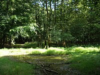
[[File:The highest point in Oxfordshire - geograph.org.uk - 1439830.jpg|left|thumb|200px|Cowleaze Wood and the county top]] | [[File:The highest point in Oxfordshire - geograph.org.uk - 1439830.jpg|left|thumb|200px|Cowleaze Wood and the county top]] | ||
Cowleaze Wood a piece of woodland on the height of Bald Hill, belonging to the Forestry Commission. It is a popular wood for walks, with a public car park at its edge. | Cowleaze Wood a piece of woodland on the height of Bald Hill, belonging to the Forestry Commission. It is a popular wood for walks, with a public car park at its edge. Cowleaze Wood is relatively flat, and placing the exact county top can be a challenge, but it lies on a footpath through the heart of the wood. | ||
Though the scarp is dramatic, and from the edges of the wood there are with amazing views over the surrounding countryside. | Though the scarp is dramatic, and from the edges of the wood there are with amazing views over the surrounding countryside. | ||
There is a great mix of habitats in this small wood and plenty of paths to explore. The bluebells in May are like a blue carpet and well worth a visit. | |||
There is a great mix of habitats in this small wood and plenty of paths to explore. The bluebells in May are like a blue carpet and well worth a visit. | |||
Until recently the natural beauty of the wood was trespassed upon by a collaboration with the Sculpture Trust, which placed sculptures within the wood. Thankfully the funding ran out and the sculptures are being removed from the woodland, which may resume its natural being. | |||
==Outside links== | ==Outside links== | ||
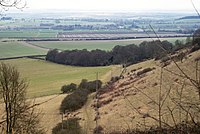
[[File:Bald Hill, Aston Rowant National Nature Reserve - geograph.org.uk - 1206666.jpg| | [[File:Bald Hill, Aston Rowant National Nature Reserve - geograph.org.uk - 1206666.jpg|thumb|200px|From Bald Hill]] | ||
*[http://www.forestry.gov.uk/website/recreation.nsf/LUWebDocsByKey/EnglandBuckinghamshireNoForestCowleaze Forestry Commission - Cowleaze] | *[http://www.forestry.gov.uk/website/recreation.nsf/LUWebDocsByKey/EnglandBuckinghamshireNoForestCowleaze Forestry Commission - Cowleaze] | ||
[[Category:County tops]] | [[Category:County tops]] | ||
Latest revision as of 17:22, 9 March 2018
| Bald Hill | |
| Oxfordshire | |
|---|---|
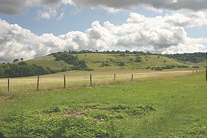
 Bald Hill from the Ridgeway path | |
| Summit: | 843 feet SU7288595775 51°39’22"N, -0°56’52"W |
Bald Hill in Oxfordshire forms part of the long escarpment of the Chilterns. Like many of the hills of the escarpment, it is barely distinguishable as an independent hill from the top, but projects out across the plain to the north-west. The top of the hill forms part of the long ridge running north-east to south-west on the top of the Chilterns, over which the road runs from west of Stokenchurch to Christmas Common.
The highest point in Oxfordshire is on Bald Hill, within Cowleaze Wood.
Cowleaze Wood

Cowleaze Wood a piece of woodland on the height of Bald Hill, belonging to the Forestry Commission. It is a popular wood for walks, with a public car park at its edge. Cowleaze Wood is relatively flat, and placing the exact county top can be a challenge, but it lies on a footpath through the heart of the wood.
Though the scarp is dramatic, and from the edges of the wood there are with amazing views over the surrounding countryside.
There is a great mix of habitats in this small wood and plenty of paths to explore. The bluebells in May are like a blue carpet and well worth a visit.
Until recently the natural beauty of the wood was trespassed upon by a collaboration with the Sculpture Trust, which placed sculptures within the wood. Thankfully the funding ran out and the sculptures are being removed from the woodland, which may resume its natural being.
Outside links
