Yarrowford: Difference between revisions
Jump to navigation
Jump to search
Created page with "{{Infobox town |name=Yarrowford |county=Selkirkshire |picture=Yarrowford.jpg |picture caption=Yarrowford |os grid ref= |latitude=55.5597 |longitude=-2.9403 |LG district=Scotti..." |
No edit summary |
||
| (One intermediate revision by the same user not shown) | |||
| Line 9: | Line 9: | ||
|LG district=Scottish Borders | |LG district=Scottish Borders | ||
}} | }} | ||
'''Yarrowford''' is a village on the A708, in [[Selkirkshire]], | '''Yarrowford''' is a village on the A708, in [[Selkirkshire]], four miles north-west of the county town, [[Selkirk]]. It is within the [[Ettrick Forest]]. | ||
The [[Yarrow Water]] flows through the village and joins the [[Ettrick Water]] near [[Philiphaugh]]. | The [[Yarrow Water]] flows through the village and joins the [[Ettrick Water]] near [[Philiphaugh]]. | ||
Places nearby include [[Bowhill, Selkirkshire|Bowhill]], [[Ettrickbridge]], [[Newark Castle, Selkirkshire|Newark Castle]], the [[Yair]] Forest, [[Yarrow]] and Yarrow Feus. | Places nearby include [[Bowhill, Selkirkshire|Bowhill]], [[Ettrickbridge]], [[Newark Castle, Selkirkshire|Newark Castle]], the [[Yair]] Forest, [[Yarrow, Selkirkshire|Yarrow]] and Yarrow Feus. | ||
==Outside links== | ==Outside links== | ||
Latest revision as of 14:15, 3 October 2017
| Yarrowford | |
| Selkirkshire | |
|---|---|
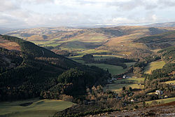
 Yarrowford | |
| Location | |
| Location: | 55°33’35"N, 2°56’25"W |
| Data | |
| Local Government | |
| Council: | Scottish Borders |
Yarrowford is a village on the A708, in Selkirkshire, four miles north-west of the county town, Selkirk. It is within the Ettrick Forest.
The Yarrow Water flows through the village and joins the Ettrick Water near Philiphaugh.
Places nearby include Bowhill, Ettrickbridge, Newark Castle, the Yair Forest, Yarrow and Yarrow Feus.
Outside links
| ("Wikimedia Commons" has material about Yarrowford) |
