Carleton, Drigg: Difference between revisions
Jump to navigation
Jump to search
Created page with "{{Infobox town |name=Carleton |county=Cumberland |picture= |picture caption= |os grid ref=SD081983 |latitude=54.372497 |longitude=-3.415577 |population= |census year= |post to..." |
No edit summary |
||
| Line 2: | Line 2: | ||
|name=Carleton | |name=Carleton | ||
|county=Cumberland | |county=Cumberland | ||
|picture= | |picture=Carleton Green, Cumberland - geograph-4394201.jpg | ||
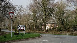
|picture caption= | |picture caption=Carleton Green and Carleton Hall | ||
|os grid ref=SD081983 | |os grid ref=SD081983 | ||
|latitude=54.372497 | |latitude=54.372497 | ||
Latest revision as of 21:54, 4 July 2017
| Carleton | |
| Cumberland | |
|---|---|
 Carleton Green and Carleton Hall | |
| Location | |
| Grid reference: | SD081983 |
| Location: | 54°22’21"N, 3°24’56"W |
| Data | |
| Postcode: | CA19 |
| Local Government | |
| Council: | Cumberland |
| Parliamentary constituency: |
Copeland |
Carleton consists a scatter of hamlets on the coast of Cumberland to the south of Drigg. The hamlets and farmsteads, including Carleton head, Hall Carleton, Amethyst Green and Cumblands, are to be found between the River Irt and the River Mite, the former bringing a tidal arm around to join the estuary of the River Esk to the south-east.

This Cumberland article is a stub: help to improve Wikishire by building it up.