Difference between revisions of "Lower Peover"
From Wikishire
(Created page with "{{Infobox town |name=Lower Peover |county=Cheshire |picture=St. Oswalds church, Lower Peover (geograph 4474412).jpg |picture caption=St Oswald's Church, Lower Peover |os grid...") |
(No difference)
|
Latest revision as of 12:54, 30 March 2017
| Lower Peover | |
| Cheshire | |
|---|---|
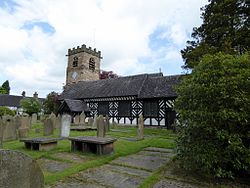
 St Oswald's Church, Lower Peover | |
| Location | |
| Grid reference: | SJ743741 |
| Location: | 53°15’58"N, 2°22’59"W |
| Data | |
| Post town: | Knutsford |
| Postcode: | WA16 |
| Dialling code: | 01565 |
| Local Government | |
| Council: | Cheshire West & Chester |
| Parliamentary constituency: |
Tatton |
Lower Peover is a little village in Cheshire, in the rural heartland of the county some six miles east of Northwich and four miles south of Knutsford. The village is on the Peover Eye, a little river which flows down to here from Over Peover, two and a half miles to the east
Lower Peover was also where George S. Patton held meetings with the senior members of the British war cabinet where they discussed plans about many military operations, most notably D-day.
Outside links
| ("Wikimedia Commons" has material about Lower Peover) |