Kyleakin: Difference between revisions
Created page with "{{Infobox town |county=Inverness |gaelic=Caol Àcain |picture=Kyleakin from Skye Bridge - geograph.org.uk - 1320683.jpg |picture caption=A view of the village, from the Skye B..." |
No edit summary |
||
| Line 13: | Line 13: | ||
|dialling code=01599 | |dialling code=01599 | ||
}} | }} | ||
'''Kyleakin''' is a village situated on the east coast of the Isle of [[Skye]] in [[Inverness-shire]]. The village is along the strait of Kyle Akin opposite the | '''Kyleakin''' is a village situated on the east coast of the Isle of [[Skye]] in [[Inverness-shire]]. The village is along the strait of Kyle Akin opposite the mainland town of [[Kyle of Lochalsh]] in [[Ross-shire]]. Kyleakin is within the parish of [[Strath]].<ref>{{cite web|url=http://www.scottish-places.info/towns/towndetails1994.html|title=Details of Kyleakin|publisher=Gazetteer for Scotland|accessdate=2 January 2015}}</ref> | ||
==History== | ==History== | ||
Latest revision as of 13:25, 21 February 2017
| Kyleakin Gaelic: Caol Àcain | |
| Inverness-shire | |
|---|---|
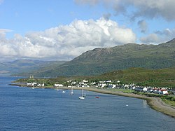
 A view of the village, from the Skye Bridge | |
| Location | |
| Grid reference: | NG752263 |
| Location: | 57°16’23"N, 5°43’41"W |
| Data | |
| Post town: | Isle of Skye |
| Postcode: | IV41 |
| Dialling code: | 01599 |
| Local Government | |
| Council: | Highland |
| Parliamentary constituency: |
Ross, Skye and Lochaber |
Kyleakin is a village situated on the east coast of the Isle of Skye in Inverness-shire. The village is along the strait of Kyle Akin opposite the mainland town of Kyle of Lochalsh in Ross-shire. Kyleakin is within the parish of Strath.[1]
History
Its name derives from 'Strait of Haakon' named after the King Haakon IV of Norway whose fleet moored there prior to the Battle of Largs in 1263 which ended Norwegian rule of the island.
In the early 19th century, Lord Macdonald conceived a grandiose plan for the development of Kyleakin, to be re-christened "New Liverpool". A contemporary print, intended to illustrate his plans, shows row upon row of tenement buildings but the project never came to fruition.

The village of Kyleakin is also the site of Castle Moil, an ruined fortress built in the late 15th century. Legend states that there were much older fortifications on the site, and that it was originally built for a Norwegian princess known as 'Saucy Mary' who would charge a toll to any boat using the narrow channel by hanging a chain from the castle to the mainland to prevent unpaid crossings. Her remains are said to be buried on the top of Beinn na Caillich (Gaelic for "mountain of the old woman"), the large mountain to the rear of the castle ruins. However, some local historians contest this and claim that she was laid to rest by another mountain of the same name a few miles west in the village of Broadford, so that she may forever face the land of her birth.
Transport
From 1841 to October 16, 1995 a ferry service operated from Kyleakin to the mainland across the narrow strait of Loch Alsh, until it was replaced by the Skye Bridge. Initially a toll bridge, the tolls were discontinued in 2004 following protests by local people.
Sport
Kyleakin plays host to Kyleakin Football Club. It hosts a new-year football match between bachelors and married men. It is also a breeding ground for shinty players.
Gallery
-
Caisteal Maol
-
The Skye Bridge spanning Kyle Akin
-
Bronze Otter at Kyleakin, by sculptor Laurence Broderick
References
- ↑ "Details of Kyleakin". Gazetteer for Scotland. http://www.scottish-places.info/towns/towndetails1994.html. Retrieved 2 January 2015.
Outside links
| ("Wikimedia Commons" has material about Kyleakin) |


