Eton Wick: Difference between revisions
Created page with "{{Infobox town |county=Buckingham |latitude=51.497 |longitude=-0.638 |LG district=Windsor and Maidenhead |post town=Windsor |postcode=SL4 |dialling code=01753 |os grid ref=SU9..." |
|||
| Line 38: | Line 38: | ||
==Further reading== | ==Further reading== | ||
*{{cite book |editor1-last=Ditchfield |editor1-first=P.H. | *{{cite book |editor1-last=Ditchfield |editor1-first=P.H.|editor2-last=Page |editor2-first=W.H. |series=[[Victoria County History]] |title=A History of the County of Buckingham, Volume 3 |year=1923 |publisher= |location= |pages=261–275 |url= http://www.british-history.ac.uk/report.aspx?compid=42557 |ref=harv}} | ||
*{{cite book |last=Pevsner |first=Nikolaus |authorlink=Nikolaus Pevsner |year=1966 |title=Buckinghamshire |series=[[Pevsner Architectural Guides#Buildings of England|The Buildings of England]] |location=Harmondsworth |publisher=Penguin Books |pages=132–133 |ref=harv}} | *{{cite book |last=Pevsner |first=Nikolaus |authorlink=Nikolaus Pevsner |year=1966 |title=Buckinghamshire |series=[[Pevsner Architectural Guides#Buildings of England|The Buildings of England]] |location=Harmondsworth |publisher=Penguin Books |pages=132–133 |ref=harv}} | ||
Latest revision as of 18:33, 5 February 2017
| Eton Wick | |
| Buckinghamshire | |
|---|---|
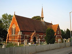
 Parish Church of St John the Baptist | |
| Location | |
| Grid reference: | SU945785 |
| Location: | 51°29’49"N, -0°38’17"W |
| Data | |
| Post town: | Windsor |
| Postcode: | SL4 |
| Dialling code: | 01753 |
| Local Government | |
| Council: | Windsor and Maidenhead |
Eton Wick is a village in Buckinghamshire, on the River Thames, which here forms the border with Berkshire. At the 2011 census the population was included in the civil parish of Eton. It is very close to both the historic towns of Windsor (Berks.) and Eton, as well as Slough and Dorney Lake, the rowing venue for the 2012 Summer Olympics. The village has grown rapidly between the 1880s and the 2000s.[1][2][3][4][5]
History
After the construction of Eton College in the 15th century, a small group of houses were built immediately west to the college grounds. Making up the homes of shoemakers, tailors, and other workers who worked in the college. The hamlet was physically separated from the rest of Eton by land owned by the college, and was known as the wick.[6]
The wick was on the very edge of the parish, on the opposite side of the border adjacent to the village, cottages were built to house farmhands working at nearby Bell Farm. Throughout the 19th century, scholars at Eton College took a personal interest in the village. Building a village hall and a small school in the village, the college was traditionally responsible for the social well-being of the settlement. [7]
In 1880, the owner of Bell Farm, Charles Dorney, sold some of his land for residential building. The new village was called Boveney New Town. After the 1894 Civil Parish act, the Wick was created as a civil parish independent from the rest of Eton. Eton Wick and Boveney New Town were almost immediately next to each other yet both retained their own councils until 1934 when they were annexed by Eton. The population of the villages during this time was around 500 [8]
After the second world war, both villages were expanded and built into each other as part of the wider national push for more housing, bringing the population up to around 3,000. In 1965 the land surrounding the village was registered as commons land under the Commons Registration Act, meaning the land cannot be developed without permission from the Secretary of State for the Environment [9]
Transport
Eton Wick shares its major transport facilities with Slough, as the route to Windsor by road is circuitous. The M4 and A4 are nearby. At Slough there is access to mainline railway services to London, and west to places such as Maidenhead, Reading and beyond.
Local rivers
As it flows from Windsor to Bray it joins with firstly Chalvey Ditch stream and Common Ditch stream to the east of Eton Wick. The River Thames then meets the Boveney Ditch stream just south east of Eton Wick. Boveney Ditch is formed by the merging of Roundmoor (drainage) Ditch and habitual dried up Cress Brook just west of Eton Wick.[10] More recently, the Jubilee River, an artificial secondary channel to the Thames, was built between Maidenhead and Windsor for flood relief. It was completed in 2002 and cuts through the Roundmoor, Chalvey and Common Ditches.[2][5][11][12]
Sport and Leisure
Eton Wick has a local football team, Eton Wick F.C., that play at Hayward's Mead.
See also
References
- ↑ "the online repository of historic maps - maps page". Old-Maps. http://www.old-maps.co.uk/maps.html?txtXCoord=496265&txtYCoord=179040. Retrieved 2012-09-18.
- ↑ 2.0 2.1 "Old maps of Britain and Europe from A Vision of Britain Through Time". Visionofbritain.org.uk. http://visionofbritain.org.uk/maps/results.jsp?xCenter=3289858.0065224&yCenter=2797262.7535504&scale=63360&mapLayer=nineteenth&subLayer=first_edition&title=Ordnance%20Survey%20and%20Ordnance%20Survey%20of%20Scotland%20First%20Series. Retrieved 2012-09-18.
- ↑ "Old maps of Britain and Europe from A Vision of Britain Through Time". Visionofbritain.org.uk. http://visionofbritain.org.uk/maps/results.jsp?xCenter=3289730.0065224&yCenter=2797198.7535504&scale=63360&mapLayer=europe&subLayer=new_pop&title=Ordnance%20Survey%20Popular%20and%20New%20Popular%20Editions. Retrieved 2012-09-18.
- ↑ "Get-a-map from Ordnance Survey". Getamap.ordnancesurvey.co.uk. http://getamap.ordnancesurvey.co.uk/getamap/frames.htm?mapAction=gaz&gazName=g&gazString=SU9453578495. Retrieved 2012-09-18.
- ↑ 5.0 5.1 "Old Ordnance Survey Maps". Ponies.me.uk. 1999-02-22. http://www.ponies.me.uk/maps/osmap.html?z=14&x=-0.638&y=51.497. Retrieved 2012-09-18.
- ↑ http://www.visitoruk.com/Maidenhead/eton-wick-and-boveney-C592-V14152.html
- ↑ http://www.visitoruk.com/Maidenhead/eton-wick-and-boveney-C592-V14152.html
- ↑ http://www.etonwickhistory.co.uk/briefhistory.html
- ↑ http://www.etonwickhistory.co.uk/briefhistory.html
- ↑ "Eton Wick: Confluence of Roundmoor Ditch with Cress Brook:: OS grid SU9478 :: Geograph Britain and Ireland - photograph every grid square!". Geograph.org.uk. http://www.geograph.org.uk/photo/1142081. Retrieved 2012-09-18.
- ↑ http://streetmap.co.uk/grid/494535_178495_120
- ↑ http://streetmap.co.uk/grid/494535_178495_106
Further reading
- Ditchfield, P.H.; Page, W.H., eds (1923). A History of the County of Buckingham, Volume 3. Victoria County History. pp. 261–275. http://www.british-history.ac.uk/report.aspx?compid=42557.
- Pevsner, Nikolaus (1966). Buckinghamshire. The Buildings of England. Harmondsworth: Penguin Books. pp. 132–133.
Outside links
| ("Wikimedia Commons" has material about Eton Wick) |
