Heaton Moor: Difference between revisions
Created page with "{{Infobox town |name=Heaton Moor |county=Lancashire |picture=Heaton moor aerial shot.jpg |picture caption=Heaton Moor |os grid ref=SJ 876 917 |latitude=53.417 |longitude..." |
mNo edit summary |
||
| Line 13: | Line 13: | ||
|constituency=Stockport | |constituency=Stockport | ||
}} | }} | ||
'''Heaton Moor''' is a suburban town of [[Lancashire]], inn the very south of the county. It is one of the [[Four Heatons]] and borders onto [[Heaton Chapel]], [[Heaton Norris]] and [[Heaton Mersey]]: series of contiguous towns of the [[Manchester]] conurbation running down to the [[River Mersey]] which marks the [[Cheshire]] border. | '''Heaton Moor''' is a suburban town of [[Lancashire]], inn the very south of the county. It is one of the [[Four Heatons]] and borders onto [[Heaton Chapel]], [[Heaton Norris]] and [[Heaton Mersey]]: a series of contiguous towns of the [[Manchester]] conurbation running down to the [[River Mersey]] which marks the [[Cheshire]] border. | ||
Heaton Moor is characterised by the affluent Victorian housing built between 1852 and 1892 along tree-lined streets which follow the field patterns of a former agricultural economy.<ref name=caa>[http://www.stockport.gov.uk/2013/2978/8803/9020/12299/heatonmoorapp Heaton Moor Conservation Area Appraisal]</ref> | Heaton Moor is characterised by the affluent Victorian housing built between 1852 and 1892 along tree-lined streets which follow the field patterns of a former agricultural economy.<ref name=caa>[http://www.stockport.gov.uk/2013/2978/8803/9020/12299/heatonmoorapp Heaton Moor Conservation Area Appraisal]</ref> | ||
Latest revision as of 23:53, 9 January 2017
| Heaton Moor | |
| Lancashire | |
|---|---|
 Heaton Moor | |
| Location | |
| Grid reference: | 8760&y=3 9170&z=120 SJ 876 917 |
| Location: | 53°25’1"N, 2°11’20"W |
| Data | |
| Post town: | Stockport |
| Postcode: | SK4 |
| Dialling code: | 0161 |
| Local Government | |
| Council: | Stockport |
| Parliamentary constituency: |
Stockport |
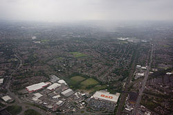
Heaton Moor is a suburban town of Lancashire, inn the very south of the county. It is one of the Four Heatons and borders onto Heaton Chapel, Heaton Norris and Heaton Mersey: a series of contiguous towns of the Manchester conurbation running down to the River Mersey which marks the Cheshire border.
Heaton Moor is characterised by the affluent Victorian housing built between 1852 and 1892 along tree-lined streets which follow the field patterns of a former agricultural economy.[1]
Heaton Moor is affluent; during the Victorian era, it had an equal residential status to Alderley Edge in Cheshire and Bowdon.[2] Today, this moneyed reputation continues as the area is typically characterised by high disposable incomes.[3]

Geography
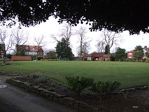
The land in Heaton Moor is predominantly flat with no rivers or streams. The soil is black and fertile as expected from land that was previously peat moor. Heaton Moor has little public open space with the exception of Heaton Moor Park and Thornfield Park, but because of its tree-lined roads and the building line set well back from the street, it gives the impression of having more space, and a Victorian business class style.[2]
Today the conservation area roads including Clifton Road and Mauldeth Road make up what is locally known as "Millionaire's Row".[4]
History


Before the opening of the railway, Heaton Moor was agricultural land in Heaton Norris. The land supported pigs, cattle and cereal. Heaton Norris was part of the Manchester barony of the Grelley family, but between 1162 and 1180 it belonged to William le Norreys.[1]
In the early 13th century, Heaton Norris was a sub manor of Manchester, it encompassed all of the Four Heatons. It was escheated (i.e. reverted) to the manor of Manchester around 1280. In 1322, there were 32 dwellings suggesting a population of 150, the ten freeholders of the escheated manor had the right to graze on common pasture and to cut wood.[5] Evidence of this pre-railway existence can be seen from the name Shaw Farm, Shaw Fold farm, and the road pattern Heaton Moor Lane, Shaw Lane, Shaw Fold Lane, Pin Fold, Green Lane. Parsonage Road and Cranbourne Grove follow the lines of ancient tracks.[1]
The opening of Heaton Chapel railway station marked a turning point in development of the area. Land was acquired, and streets were planned. The houses and new buildings along Heaton Moor Road were of a grandiose scale with generous gardens. They are set back from the road, and have imposing stone gate posts. The new residential roads such as Broomfield Road, Derby Road, and Peel Moat Road which were built when agricultural land was acquired, have the same characteristics. The building and infilling continued into the Edwardian era. There were a wide range of sporting facilities, such as crown green bowling, tennis and golf. A substantial terrace of shops was built on Heaton Moor Road, with glass and cast iron awnings. Intellectual life was provided for when the Reform Club was built in 1886 by Alfred Darbyshire.[1]
The Savoy Cinema opened 1923, built in the Baroque style in red brick with white terracota dressings.[1] When in 2006 the cinema announced its closure due to low audiences,[6] there was uproar amongst locals. It was announced it could be replaced by a Varsity bar.[7] A campaign entitled 'Save Our Savoy' was launched.[8] Plans were rejected.[9] It has new owners, has been refurbished and reopened in 2015.[10]
A second hub was built around Thornfield, the former town hall at Moor Top. The main thoroughfare is now home to wine bars, boutiques, florists and upmarket restaurants, including Damson, Avanti and Bo Wa.
Mauldeth Hall
Mauldeth Hall is a large Greek Revival villa, built in 1832-60, for Joseph Chessborough Dyer; extended in 1880-82 by Charles Heathcote so that it could become a "hospital for incurables". After it became derelict in the late 20th century the hall was converted to offices; most of the park and gardens of the hall have been taken over by Heaton Moor Golf Club. On Mauldeth Road is a classical lodge (probably also by Heathcote).[11] It has been a Grade II listed building since 1975.[12]
The original owner was obliged to sell the hall in the early 1840s and it was acquired by Edmund Wright (1781-1852) as his residence. It was then named Leegate Hall but Wright renamed it Heaton Hall; since there was also a Heaton Hall at Prestwich he renamed it again as Mauldeth Hall. On the death of Edmund Wright in 1852 the hall was acquired by the Ecclesiastical Commissioners as the residence of the first Bishop of Manchester. The bishop was James Prince Lee, bishop since 1848, who lived in the hall until his death in 1869.[13] In 1915 the Hospital for Incurables at Mauldeth Hall and Walmersley House had accommodation for 125 inpatients.[14]
Churches

- Church of England:
- St Paul's Church, built 1876 by Bird and Whittenbury, extended in 1896 and the octagonal tower added in 1900 by EP Oakley.
- Coptic: Virgin St Mary and St Mina built 1896 by Derbyshire and Smith as a Congregationalist Church
- Methodist / United Reformed Church: Heaton Moor United Church
- Independent / Evangelical: Emmanuel Community Church
Sport
- Bowling, Tennis and Squash: West Heaton Bowling, Tennis and Squash Club, established in 1873
- Golf: Heaton Moor Golf Club, founded in 1892
- Lacrosse: Heaton Mersey (playing in Heaton Moor)
- Rugby: Heaton Moor Rugby Club
See also
Outside links
| ("Wikimedia Commons" has material about Heaton Moor) |
- Heaton Moor Conservation Area Appraisal
- heatonmoor.com - All the Moor
- onthemoor.com – On The Moor for the Four Heatons
- On the Moor - blog
References
- ↑ 1.0 1.1 1.2 1.3 Heaton Moor Conservation Area Appraisal
- ↑ 2.0 2.1 Rogers, H B: 'The Suburban Growth of Victorian Manchester' - The Manchester Geographical Society
- ↑ http://neighbourhood.statistics.gov.uk/dissemination/LeadHome.do?m=0&s=1378904512622&enc=1&nsjs=true&nsck=false&nssvg=false&nswid=1440
- ↑ "Million pound estate in Heaton Moor". Manchester Evening News. June 2010. http://www.stockport.gov.uk/services/environment/planningbuilding/conservationheritage/conservationareas/conservationareaappraisalsmanagementplans/mauldethroad. Retrieved 25 September 2013.
- ↑ Mediæval and early modern Manchester, G.H.Tupling in Manchester and its region, pub The British Association and Manchester University Press 1962
- ↑ Payne, Eileen (2 August 2006). "Savoy cinema faces last picture show". Stockport Express (Guardian Media Group). http://www.stockportexpress.co.uk/news/s/215/215908_savoy_cinema_faces_last_picture_show.html. Retrieved 2006-10-15.
- ↑ Payne, Eileen (23 August 2006). "Campaign to save the Savoy is stepped up". Stockport Express (Guardian Media Group). http://www.stockportexpress.co.uk/news/s/216/216709_campaign_to_save_the_savoy_is_stepped_up.html. Retrieved 2006-10-15.
- ↑ "Save the Savoy! Community try to save legendary Stockport site". Dial2Donate. http://dial2donate.org/save-savoy-community-try-save-legendary-stockport-site/. Retrieved 21 August 2015.
- ↑ Payne, Eileen (11 October 2006). "Plan to turn Savoy into pub rejected". Stockport Express (Guardian Media Group). http://www.stockportexpress.co.uk/news/s/218/218536_plan_to_turn_savoy_into_pub_rejected.html. Retrieved 2006-10-15.
- ↑ Cinema Treasures accessed=2016-01-26.
- ↑ Nikolaus Pevsner: Pevsner Architectural Guides
- ↑ Mauldeth Hall - British Listed Buildings
- ↑ South Manchester Reporter; 28 February 2013, p. 19
- ↑ McKechnie, H. M., ed. (1915) Manchester in Nineteen Hundred and Fifteen. Manchester University Press; p. 58
