Boarstall: Difference between revisions
Created page with '{{Infobox town |name=Boarstall |county=Buckinghamshire |picture=Boarstall Tower.jpg |picture caption=Boarstall Tower |os grid ref=SP6214 |latitude=51.823 |longitude=-1.092 |popul…' |
|||
| Line 47: | Line 47: | ||
{{reflist}} | {{reflist}} | ||
*{{cite book |last1=Lysons |first1=Daniel | *{{cite book |last1=Lysons |first1=Daniel |last2=Lysons |first2=Samuel |title=Magna Britannia: being a concise topographical account of the several counties of Great Britain |volume=1. Containing Bedfordshire, Berkshire, and Buckinghamshire |year=1806 |publisher=|location=|pages=|ref=harv}} | ||
*{{cite book |editor-last=Page |editor-first=W.H. | *{{cite book |editor-last=Page |editor-first=W.H. |series=[[Victoria County History]] |title=A History of the County of Buckingham, Volume 4 |year=1927 |publisher=|location=|pages=|ref=harv}} | ||
*{{cite book |last=Pevsner |first=Nikolaus | *{{cite book |last=Pevsner |first=Nikolaus |series=[[Pevsner Architectural Guides#Buildings of England|The Buildings of England]] |title=Buckinghamshire |origyear=1966 |year=1973 |publisher=Penguin Books |location=Harmondsworth |isbn=0-14-071019-1 |pages=68–69 |ref=harv}} | ||
*{{cite book |last=Reed |first=Michael |editor1-last=Hoskins |editor1-first=W.G. | *{{cite book |last=Reed |first=Michael |editor1-last=Hoskins |editor1-first=W.G. |editor2-last=Millward |editor2-first=Roy |title=The Buckinghamshire Landscape |series=The Making of the English Landscape |year=1979 |publisher=Hodder & Stoughton |location=London |isbn=0-340-19044-2 |pages=41, 74, 81, 118, 121, 122, 127, 135, 195–197, |ref=harv}} | ||
[[Category:Gardens by Capability Brown]] | [[Category:Gardens by Capability Brown]] | ||
Latest revision as of 19:58, 22 December 2016
| Boarstall | |
| Buckinghamshire | |
|---|---|
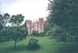
 Boarstall Tower | |
| Location | |
| Grid reference: | SP6214 |
| Location: | 51°49’23"N, 1°5’31"W |
| Data | |
| Population: | 128 (2011) |
| Post town: | Aylesbury |
| Postcode: | HP18 |
| Dialling code: | 01844 |
| Local Government | |
| Council: | Buckinghamshire |
| Parliamentary constituency: |
Buckingham |
| Website: | Boarstall.com |
Boarstall is a village and in Buckinghamshire, about 12 miles west of Aylesbury. The parish nestles against the county boundary with Oxfordshire and the village is onky about 5½ miles southeast of the Oxfordshire market town of Bicester.
History
According to legend King Edward the Confessor gave some land to one of his men in return for slaying a wild boar that had infested the nearby Bernwood Forest. The man built himself a mansion on this land and called it "Boar-stall" in memory of the slain beast. The man was also given a horn from the dead beast, and the legend says that whoever shall possess the horn shall be the lord of the manor of Boarstall.
It is certainly the case from manorial records of 1265 that the owner of the manor of Boarstall was the ceremonial keeper of the Bernwood Forest, suggesting a link with the earlier legend.
The Magna Britannia of 1806 noted that the current incumbent of the manor, Sir John Aubrey, was in possession of a large horn
"of a dark brown colour, variegated and veined like tortoise-shell. It is two feet four inches in length, on the convex bend, the diameter of the larger end is three inches; at each end it is tipt with silver, gilt, and has a wreath of leather, by which it is hung about the neck".
The manor was fortified in 1312 by the construction of a defensive gatehouse. The house was demolished in 1778 but the gatehouse, very large and grand for its time, survives relatively unaltered. Boarstall Tower, which was originally part of the 18th century house on the site, was given to the National Trust by the philanthropist Ernest Cook, founder of the Ernest Cook Trust. In the Civil War the tower was made into a garrison by King Charles I who was in possession of the nearby town of Brill When the king's manor of Brill fell in 1643, so did the garrison at Boarstall. However while the manor house at Brill was destroyed in the fighting, the fortified manor at Boarstall was saved, and used as a garrison by John Hampden's men, from which they were able to attack Royalist Oxford, 8 miles away.
Having no further use for the manor in 1644, Hampden left to go and fight elsewhere. The house was then taken back for the Royalists by Colonel Henry Gage, whom it is said launched such heavy fire from his cannons against the house that the incumbent Lady Denham was forced to evacuate and steal away in disguise. Gage left a small garrison in place to defend the house.
In May 1645 the house was attacked again by the Parliamentarian forces, this time led by Sir Thomas Fairfax, but he was unsuccessful. The following year in 1646 Fairfax returned, and the house was surrendered to him on 10 June, after a siege of 18 hours.
Ecclesiastically, Boarstall's church was originally a chapel of ease for nearby Oakley, and its tithes were granted by Empress Matilda to St Frideswide's monastery in Oxford. The parish of Boarstall was formed in 1418.
The original parish church was mainly demolished in the Civil War but a replacement was constructed out of funds provided by Lady Denham.
Sights 0f the village
Outside links
| ("Wikimedia Commons" has material about Boarstall) |
References
- Lysons, Daniel; Lysons, Samuel (1806). Magna Britannia: being a concise topographical account of the several counties of Great Britain. 1. Containing Bedfordshire, Berkshire, and Buckinghamshire.
- Page, W.H., ed (1927). A History of the County of Buckingham, Volume 4. Victoria County History.
- Pevsner, Nikolaus (1973) [1966]. Buckinghamshire. The Buildings of England. Harmondsworth: Penguin Books. pp. 68–69. ISBN 0-14-071019-1.
- Reed, Michael (1979). Hoskins, W.G.; Millward, Roy. eds. The Buckinghamshire Landscape. The Making of the English Landscape. London: Hodder & Stoughton. pp. 41, 74, 81, 118, 121, 122, 127, 135, 195–197,. ISBN 0-340-19044-2.
