Difference between revisions of "Antony"
(Created page with '{{Infobox town |name=Antony |cornish=Trevanta |county=Cornwall |picture=Antony Village - geograph.org.uk - 72439.jpg |picture caption=Antony village and parish church |os grid re…') |
m |
||
| (One intermediate revision by the same user not shown) | |||
| Line 16: | Line 16: | ||
|constituency=South East Cornwall | |constituency=South East Cornwall | ||
}} | }} | ||
| − | '''Antony''' is a coastal village on the [[Rame Peninsula]] of [[Cornwall]]. Antony is also the name of the stately home, Antony House, and estate to the northeast of the village, which are owned by the [[National Trust for Places of Historic Interest or Natural Beauty|National Trust]]. | + | '''Antony''' is a coastal village on the [[Rame Peninsula]] of [[Cornwall]]. Antony is also the name of the stately home, [[Antony House]], and estate to the northeast of the village, which are owned by the [[National Trust for Places of Historic Interest or Natural Beauty|National Trust]]. |
The village is about three miles west of [[Torpoint]], on the north shore of the peninsula, where the [[River Lynher#St Germans River|St Germans River]], broad and tidal, divides Rame from the body of the county, and here the village obverlooks its extensive mudflats at low water. The village is small, but has a shop, a pub and a garage. | The village is about three miles west of [[Torpoint]], on the north shore of the peninsula, where the [[River Lynher#St Germans River|St Germans River]], broad and tidal, divides Rame from the body of the county, and here the village obverlooks its extensive mudflats at low water. The village is small, but has a shop, a pub and a garage. | ||
| Line 22: | Line 22: | ||
Antony parish is bounded to the north by the St Germans or Lynher River and to the south by the [[English Channel]] coast. To the east, the parish is bordered by [[Torpoint]] and [[St John, Cornwall|St John]] parishes and to the west by [[Sheviock]] parish. | Antony parish is bounded to the north by the St Germans or Lynher River and to the south by the [[English Channel]] coast. To the east, the parish is bordered by [[Torpoint]] and [[St John, Cornwall|St John]] parishes and to the west by [[Sheviock]] parish. | ||
| − | Apart from the church town, Antony, the only settlement of any size is [[Wilcove]]. [[Scraesdon Fort]]. | + | Apart from the church town, Antony, the only settlement of any size is [[Wilcove]]. [[Scraesdon Fort]] and Antony House are also in the parish. |
==Parish church== | ==Parish church== | ||
| Line 31: | Line 31: | ||
{{clear}} | {{clear}} | ||
==Antony House== | ==Antony House== | ||
| − | {{ | + | {{Main|Antony House}} |
| − | | | + | [[File:Antony House 03.jpg|right|thumb|250px|Antony House]] |
| − | + | ||
| − | + | ||
| − | | | + | |
| − | | | + | |
| − | + | ||
'''Antony''' is an estate on the Rame Peninsula of [[Cornwall]] which belongs to the [[National Trust for Places of Historic Interest or Natural Beauty|National Trust]]. | '''Antony''' is an estate on the Rame Peninsula of [[Cornwall]] which belongs to the [[National Trust for Places of Historic Interest or Natural Beauty|National Trust]]. | ||
| Line 53: | Line 48: | ||
==Outside links== | ==Outside links== | ||
| − | + | {{Commons|Antony, Cornwall}} | |
| − | *{{NT link}} – National Trust | + | *{{NT link|Antony}} – National Trust |
*{{OpenDomesday|SX3954|antony|Antony}} | *{{OpenDomesday|SX3954|antony|Antony}} | ||
==References== | ==References== | ||
{{Reflist}} | {{Reflist}} | ||
Latest revision as of 16:50, 20 September 2016
| Antony Cornish: Trevanta | |
| Cornwall | |
|---|---|
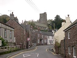
 Antony village and parish church | |
| Location | |
| Grid reference: | SX399547 |
| Location: | 50°22’12"N, 4°15’7"W |
| Data | |
| Population: | 436 (2001) |
| Post town: | Torpoint |
| Postcode: | PL11 |
| Dialling code: | 01752 |
| Local Government | |
| Council: | Cornwall |
| Parliamentary constituency: |
South East Cornwall |
Antony is a coastal village on the Rame Peninsula of Cornwall. Antony is also the name of the stately home, Antony House, and estate to the northeast of the village, which are owned by the National Trust.
The village is about three miles west of Torpoint, on the north shore of the peninsula, where the St Germans River, broad and tidal, divides Rame from the body of the county, and here the village obverlooks its extensive mudflats at low water. The village is small, but has a shop, a pub and a garage.
Antony parish is bounded to the north by the St Germans or Lynher River and to the south by the English Channel coast. To the east, the parish is bordered by Torpoint and St John parishes and to the west by Sheviock parish.
Apart from the church town, Antony, the only settlement of any size is Wilcove. Scraesdon Fort and Antony House are also in the parish.
Parish church
The parish church is St James, a mediæval church which includes structural elements from the 13th, 14th and 15th centuries.
The church has memorials to members of the Carew family of Antony (18th century), whose seat is Antony House, and a large monumental brass to Margery Arundell, 1420.[1]
Antony House
- Main article: Antony House
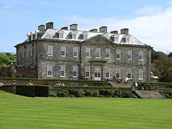
Antony is an estate on the Rame Peninsula of Cornwall which belongs to the National Trust.
The estate is a mile and a half northeast of Antony village, on the north shore of the peninsula, a little before the Lynher or St Germans River enters the Hamoaze, the Tamar roads opposite Devonport. The Lynher estuary narrows a little here to make a clear flow and enabling the estate to have a jetty into the river.
The house was and remains the home of the Carew Pole family. It was developed as the family seat, a beautiful house in the classical style, faced in silver-grey Pentewan stone and flanked by colonnaded wings of mellow brick. It contains fine collections of paintings, furniture and textiles.
The grounds bordering the St Germans River estuary was landscaped by Repton, and include a formal garden with topiary, a knot garden, modern sculptures and the National Collection of Daylilies.
The Woodland Garden, owned and run by the Carew Pole Garden Trust, has outstanding rhododendrons, azaleas, magnolias and camellias.
Part of the house and gardens are reserved to the family, but otherwise they are a National Trust property for the public.
Antony was used as the film set for Walt Disney's Alice in Wonderland (2010)[2]
Outside links
| ("Wikimedia Commons" has material about Antony) |
- Antony – National Trust
- Antony in the Domesday Book
References
- ↑ Pevsner, N. (1970) Cornwall, Second edition. Penguin Books; pp. 36-37
- ↑ Alice in Wonderland at the Internet Movie Database
