Ae Bridgend: Difference between revisions
Jump to navigation
Jump to search
Created page with "{{Infobox town |name=Ae Bridgend |county=Dumfriesshire |picture= |picture caption= |os grid ref=NY011868 |latitude=55.16559 |longitude=-3.55403 |postcode= |post town= |populat..." |
No edit summary |
||
| Line 2: | Line 2: | ||
|name=Ae Bridgend | |name=Ae Bridgend | ||
|county=Dumfriesshire | |county=Dumfriesshire | ||
|picture= | |picture=Ae Bridgend, Dumfriesshire - geograph-4385819.jpg | ||
|picture caption= | |picture caption= | ||
|os grid ref=NY011868 | |os grid ref=NY011868 | ||
| Line 19: | Line 19: | ||
==Outside links== | ==Outside links== | ||
{{commons}} | |||
Latest revision as of 19:48, 22 June 2016
| Ae Bridgend | |
| Dumfriesshire | |
|---|---|

| |
| Location | |
| Grid reference: | NY011868 |
| Location: | 55°9’56"N, 3°33’15"W |
| Data | |
| Local Government | |
| Council: | Dumfries and Galloway |
| Parliamentary constituency: |
Dumfries and Galloway |
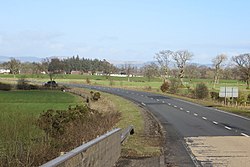
Ae Bridgend is a hamlet in Dumfriesshire on the Water of Ae, where the river is bridged by the A701, the main road between Dumfries and Moffat, just south of Parkgate.
This location is several miles downstream from Ae village
Outside links
| ("Wikimedia Commons" has material about Ae Bridgend) |
