Luton: Difference between revisions
Created page with '{{Infobox settlement | name = Luton | county=Bedfordshire | picture= Luton Town Hallb.jpg | picture caption=Luton Town Hall | arms= Luton Crest.jpg | postcode = LU | dialling cod…' |
m clean up, typos fixed: horse drawn → horse-drawn |
||
| (4 intermediate revisions by 2 users not shown) | |||
| Line 1: | Line 1: | ||
{{Infobox | {{Infobox town | ||
| name = Luton | | name = Luton | ||
| county=Bedfordshire | | county=Bedfordshire | ||
| population=184,390 | |||
| latitude=51.9 | |||
| longitude=-0.43 | |||
| picture= Luton Town Hallb.jpg | | picture= Luton Town Hallb.jpg | ||
| picture caption=Luton Town Hall | | picture caption=Luton Town Hall | ||
| Line 9: | Line 12: | ||
| LG district = Luton | | LG district = Luton | ||
}} | }} | ||
'''Luton''' is the largest town in [[Bedfordshire]]. Luton and its near neighbours, [[Dunstable]] and [[Houghton Regis]], form the Luton-Dunstable urban area with a population of over 240,000.<ref name=pop2009>Luton Borough Council, [http://www.luton.gov.uk/media%20library/pdf/environment%20&%20regeneration/planning/observatory/2009%20ons%20mid%20year%20population%20estimates.pdf 2009 Mid year population estimates for Luton].</ref><ref>Central Bedfordshire Council, [http://www.centralbedfordshire.gov.uk/images/100623%20web%20population%202009_tcm5-29976.pdf Central Bedfordshire's population]. Dunstable 35,120. Houghton Regis 16,670.</ref> | '''Luton''' is the largest town in [[Bedfordshire]]. Luton and its near neighbours, [[Dunstable]] and [[Houghton Regis]], form the Luton-Dunstable urban area with a population of over 240,000.<ref name=pop2009>Luton Borough Council, [http://www.luton.gov.uk/media%20library/pdf/environment%20&%20regeneration/planning/observatory/2009%20ons%20mid%20year%20population%20estimates.pdf 2009 Mid year population estimates for Luton].</ref><ref>Central Bedfordshire Council, [http://www.centralbedfordshire.gov.uk/images/100623%20web%20population%202009_tcm5-29976.pdf Central Bedfordshire's population]. Dunstable 35,120. Houghton Regis 16,670.</ref> | ||
| Line 38: | Line 40: | ||
===Early history=== | ===Early history=== | ||
Palaeolithic encampments some 250,000 years old) have been found at Luton<ref>Dyer J, Stygall F, Dony J, ''The Story of Luton'', Luton, 1964, p 20</ref> and later mesolithic (8000 BC) and neolithic (4500-2500 BC) settlements too (at Galley Hill in particular)<ref>Dyer ''ibid'', p 23</ref> | Palaeolithic encampments some 250,000 years old) have been found at Luton<ref>Dyer J, Stygall F, Dony J, ''The Story of Luton'', Luton, 1964, p 20</ref> and later mesolithic (8000 BC) and neolithic (4500-2500 BC) settlements too (at Galley Hill in particular);<ref>Dyer ''ibid'', p 23</ref> [[Waulud's Bank]] is stone-age henge dating from around 3000 BC. The Romans established a town at [[Dunstable]], ''Durocobrivis'', but where Luton now stands were at that time only of scattered farmsteads.<ref>Dyer ''ibid'', p 31</ref> | ||
Luton was founded probably in the 6th century by Anglo-Saxon settlers on the River Lea, who naed it ''Ligtun''.<ref>{{cite web|url=http://www.localhistories.org/luton.html |title=Early history of Luton|accessdate=2008-06-16}}</ref> Luton is recorded in the [[Domesday Book]] as ''Loitone'' and also as ''Lintone''.<ref>{{cite web|url=http://www.domesdaybook.co.uk/bedfordshire2.html|title=Doomsday book record|accessdate=2008-06-16}}</ref> Agriculture dominated the local economy at that time, and the town's population was around 700-800. | Luton was founded probably in the 6th century by Anglo-Saxon settlers on the River Lea, who naed it ''Ligtun''.<ref>{{cite web|url=http://www.localhistories.org/luton.html |title=Early history of Luton|accessdate=2008-06-16}}</ref> Luton is recorded in the [[Domesday Book]] as ''Loitone'' and also as ''Lintone''.<ref>{{cite web|url=http://www.domesdaybook.co.uk/bedfordshire2.html|title=Doomsday book record|accessdate=2008-06-16}}</ref> Agriculture dominated the local economy at that time, and the town's population was around 700-800. | ||
| Line 44: | Line 46: | ||
[[File:StMarysLuton.jpg|thumb|right|St Marys Church]] | [[File:StMarysLuton.jpg|thumb|right|St Marys Church]] | ||
[[File:Wenlock chapel, Luton.jpg|thumb|right|The Wenlock chapel within St Marys]] | [[File:Wenlock chapel, Luton.jpg|thumb|right|The Wenlock chapel within St Marys]] | ||
In 1121 Robert, 1st Earl of Gloucester started work on St Mary's Church in the centre of the town. The work was completed by 1137.<ref>{{cite web|url=http://stmarysluton.org/page2.html |title=History of St Mary's Church |accessdate=2008-06-16}}</ref> A motte and bailey type castle was built in 1139 (now Castle Street) but was demolished in 1154<ref>{{cite web|url=http://www.shoutluton.com/page8.html |title=Luton Castle only lasted 15 years|accessdate=2008-06-16}}</ref> | In 1121 Robert, 1st Earl of Gloucester started work on St Mary's Church in the centre of the town. The work was completed by 1137.<ref>{{cite web|url=http://stmarysluton.org/page2.html |title=History of St Mary's Church |accessdate=2008-06-16}}</ref> A motte and bailey type castle was built in 1139 (now Castle Street) but was demolished in 1154.<ref>{{cite web|url=http://www.shoutluton.com/page8.html |title=Luton Castle only lasted 15 years|accessdate=2008-06-16}}</ref> During the Middle Ages Luton is recorded as being home to six watermills, which give Mill Street in the town centre its name. | ||
In return for his military services, King John granted Falkes de Breauté the manor of Luton, where he built a castle alongside St Mary's Church. His house received the name "Fawkes Hall", subsequently corrupted over the years to "Foxhall", then "Vauxhall". His heraldic badge was the mythical griffin, which thus became associated with both Luton in the early 13th century and provides the badge of Vauxhall Motors.<ref>{{cite web|url=http://www.vauxhallandkennington.org.uk/history.shtml |title=Vauxhall history|accessdate=2008-06-16}}</ref> | In return for his military services, King John granted Falkes de Breauté the manor of Luton, where he built a castle alongside St Mary's Church. His house received the name "Fawkes Hall", subsequently corrupted over the years to "Foxhall", then "Vauxhall". His heraldic badge was the mythical griffin, which thus became associated with both Luton in the early 13th century and provides the badge of Vauxhall Motors.<ref>{{cite web|url=http://www.vauxhallandkennington.org.uk/history.shtml |title=Vauxhall history|accessdate=2008-06-16}}</ref> | ||
| Line 73: | Line 75: | ||
===20th century=== | ===20th century=== | ||
[[File:Wardownmuseum.jpg|thumb|right| | [[File:Wardownmuseum.jpg|thumb|right|200px|Luton Museum & Art Gallery]] | ||
In the 20th century, the hat trade severely declined and was replaced by other industries. In 1905, Vauxhall Motors opened the largest car plant in the United Kingdom in Luton. Electrolux built a household appliances plant which was followed by other light engineering businesses. | In the 20th century, the hat trade severely declined and was replaced by other industries. In 1905, Vauxhall Motors opened the largest car plant in the United Kingdom in Luton. Electrolux built a household appliances plant which was followed by other light engineering businesses. | ||
| Line 88: | Line 90: | ||
==Wardown Park== | ==Wardown Park== | ||
[[File:Daisy-Chain-Walk-standard.jpg|thumb|left|The Daisy-Chain Wall in | [[File:Daisy-Chain-Walk-standard.jpg|thumb|left|200px|The Daisy-Chain Wall in Wardown Park]] | ||
Wardown Park is situated on the [[River Lea]] in Luton. The park has sporting facilities, is home to the Luton Museum and Art Gallery and contains formal gardens. The park is located between ''Old Bedford Road'' and the A6, ''New Bedford Road'' and is within walking distance of the town centre.<ref>{{cite web|url=http://www.luton.gov.uk/internet/Leisure_and_culture/Museums_and_galleries/Wardown%20Park|title= Luton Council website|accessdate=2008-06-16}}</ref> | Wardown Park is situated on the [[River Lea]] in Luton. The park has sporting facilities, is home to the Luton Museum and Art Gallery and contains formal gardens. The park is located between ''Old Bedford Road'' and the A6, ''New Bedford Road'' and is within walking distance of the town centre.<ref>{{cite web|url=http://www.luton.gov.uk/internet/Leisure_and_culture/Museums_and_galleries/Wardown%20Park|title= Luton Council website|accessdate=2008-06-16}}</ref> | ||
| Line 121: | Line 123: | ||
The Mossman Carriage collection is held at Stockwood Park, Luton and is the largest and most significant vehicle collection of its kind in the country, including originals from the 18th, 19th and 20th centuries. | The Mossman Carriage collection is held at Stockwood Park, Luton and is the largest and most significant vehicle collection of its kind in the country, including originals from the 18th, 19th and 20th centuries. | ||
The Mossman collection of horse drawn vehicles was given to Luton Museum Service in 1991. It illustrates the development of horse-drawn road transportation in Britain from Roman times up until the 1930s. | The Mossman collection of horse-drawn vehicles was given to Luton Museum Service in 1991. It illustrates the development of horse-drawn road transportation in Britain from Roman times up until the 1930s. | ||
==References== | ==References== | ||
{{Reflist | {{Reflist}} | ||
== | == Outside links == | ||
* [http://lutonlive.com/ Luton Live] | * [http://lutonlive.com/ Luton Live] | ||
Latest revision as of 12:51, 27 January 2016
| Luton | |
| Bedfordshire | |
|---|---|
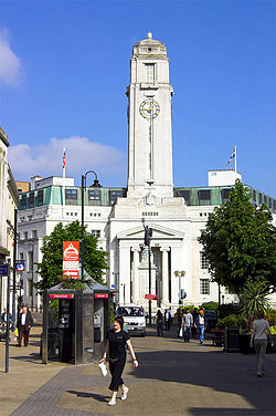 Luton Town Hall | |
| Location | |
| Location: | 51°54’-0"N, 0°25’48"W |
| Data | |
| Population: | 184,390 |
| Postcode: | LU |
| Dialling code: | 01582 |
| Local Government | |
| Council: | Luton |
Luton is the largest town in Bedfordshire. Luton and its near neighbours, Dunstable and Houghton Regis, form the Luton-Dunstable urban area with a population of over 240,000.[1][2]
The town was for many years famous for hat-making and outside the town was a large brick-making area, taking advantage of the clay deposits in the east of the town. Its economy increased to a wide variety of further industries in the twentieth century, including car making and engineering. Luton is now moving towards an economy based on light industry, services (particularly in the retail sector) and industry related to its airport.
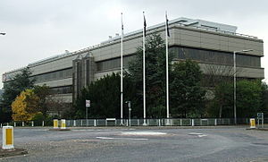
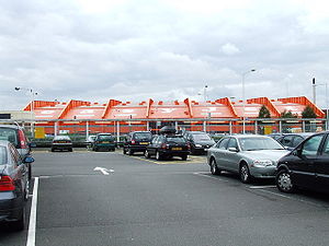
The head office of Vauxhall Motors is still situated in Luton. Car production at the Vauxhall plant began in 1905 and continued until 2002. Commercial vehicle production remains active in Luton.
Geography
Luton is located in a break in the Eastern part of the Chiltern Hills.
The source of the River Lea is in the Leagrave area of the town. The Great Bramingham Wood which surrounds this area is classified as ancient woodland.
There are few routes through the hilly area for some miles, this has led to several major roads, including the M1 motorway and the A6, the A6 itself following an ancient route; that of the Roman Road, Watling Street. A major rail-link is being constructed through the town.
Quick facts
- Luton Airport, opened in 1938, is one of Britain's major airports. During the Second World War it doubled as a Royal Air Force base. It was renamed "London Luton Airport" in 1990.
- Luton Town Football Club play at Kenilworth Road stadium, their home since 1905. They have had several spells in the top flight of the English league as well as a Football League Cup triumph in 1988.
- The Luton Carnival, held on the late May bank holiday, is one of the largest carnivals in Britain.
- The University of Bedfordshire is based in the town.
History
Early history
Palaeolithic encampments some 250,000 years old) have been found at Luton[3] and later mesolithic (8000 BC) and neolithic (4500-2500 BC) settlements too (at Galley Hill in particular);[4] Waulud's Bank is stone-age henge dating from around 3000 BC. The Romans established a town at Dunstable, Durocobrivis, but where Luton now stands were at that time only of scattered farmsteads.[5]
Luton was founded probably in the 6th century by Anglo-Saxon settlers on the River Lea, who naed it Ligtun.[6] Luton is recorded in the Domesday Book as Loitone and also as Lintone.[7] Agriculture dominated the local economy at that time, and the town's population was around 700-800.
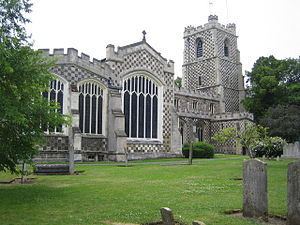
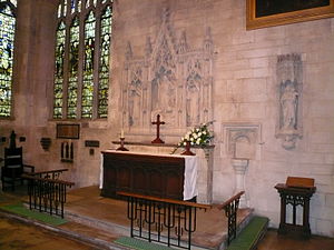
In 1121 Robert, 1st Earl of Gloucester started work on St Mary's Church in the centre of the town. The work was completed by 1137.[8] A motte and bailey type castle was built in 1139 (now Castle Street) but was demolished in 1154.[9] During the Middle Ages Luton is recorded as being home to six watermills, which give Mill Street in the town centre its name.
In return for his military services, King John granted Falkes de Breauté the manor of Luton, where he built a castle alongside St Mary's Church. His house received the name "Fawkes Hall", subsequently corrupted over the years to "Foxhall", then "Vauxhall". His heraldic badge was the mythical griffin, which thus became associated with both Luton in the early 13th century and provides the badge of Vauxhall Motors.[10]
By 1240 the town is recorded as Leueton. The town had a market for surrounding villages in August each year. In 1336, much of Luton was destroyed by a great fire, but was soon rebuilt, and with the growth of the town a second fair was granted each October from 1338.
The agriculture base of the town changed in the 16th century as a brick-making industry developed around Luton. Many of the older wooden houses were rebuilt in brick.
17th century
In 1645 during the English Civil War royalist soldiers entered Luton. Parliamentary forces arrived soon after and during the fighting four royalist soldiers were killed and a further twenty-two were captured. A second skirmish occurred three years later in 1648 when a royalist army passed through Luton. A number of royalists were attacked by parliamentary soldiers at an inn on the corner of the current Bridge Street. Most of the royalists escaped but nine were killed.
18th century
The hat making industry began in the 17th century and became synonymous with the town.[11] By the 18th century the industry dominated the town. Hats are still produced in the town but on a much smaller scale.
The first Luton Workhouse was constructed in the town in 1722.
Luton Hoo, a nearby large country house was built in 1767 and substantially rebuilt after a fire in 1843. It is now a luxury hotel.[12]
19th century
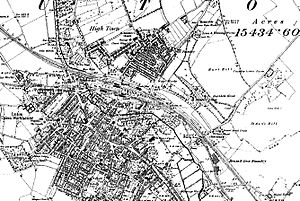
The town grew strongly in the 19th century. In 1801 the population was 3,095.[13] By 1850 it was over 10,000 and by 1901 it was almost 39,000. Such rapid growth demanded a railway connection but the town had to wait a long time for one. The London and Birmingham Railway (L&BR) had been built through Tring in 1838, and the Great Northern Railway was built through Hitchin in 1852, both bypassing Luton, the largest town in the area. A branch line connecting with the L&BR at Leighton Buzzard was proposed, but because of objections to release of land, construction terminated at Dunstable in 1848. It was another ten years before the branch was extended to Bute Street Station, and the first train to Dunstable ran on 3 May 1858.[14] The line was later extended to Welwyn and from 1860 direct trains to King's Cross, London ran. The Midland Railway was extended from Bedford to St Pancras, London through Leagrave and Midland Road station and opened on 9 September 1867.[15]
Luton received a gas supply in 1834. Gas street lights were erected and the first town hall was opened in 1847.
Newspaper printing arrived in the town in 1854. The first public cemetery was opened in the same year. Following a cholera epidemic in 1848 Luton formed a water company and had a complete water and sewerage system by the late 1860s. The first covered market was built (the Plait Halls - now demolished) in 1869.
20th century
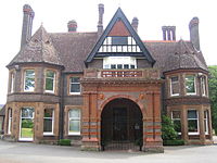
In the 20th century, the hat trade severely declined and was replaced by other industries. In 1905, Vauxhall Motors opened the largest car plant in the United Kingdom in Luton. Electrolux built a household appliances plant which was followed by other light engineering businesses.
The original town hall was destroyed in 1919 during Peace Day celebrations at the end of the First World War I: local people including many ex-servicemen, unhappy with unemployment, had been refused the use of a local park to hold celebratory events, so they stormed the town hall and burnt it down. A replacement building was completed in 1936. Luton Airport opened in 1938, owned and operated by the council.
Luton Municipal Airport was opened on 16 July 1938.
During the Second World War the Vauxhall Factory built Churchill tanks[16] as part of the war effort, resulting in a number of air raids in which a hundred and seven died[17] and there was extensive damage to the town (over 1,500 homes were damaged or destroyed). Other industry in the town, such as SKF, which produced ball bearings, made a vital contribution to the war effort. One bomb landed at the SKF Factory[18] no major damage was caused. Luton Airport served as a Royal Air Force base during the war.
After the war, slum clearance changed the face of the town and new estates were built.
In 2000, Vauxhall announced the end of car production in Luton; the plant closed in March 2002.[19] At its peak it had employed in excess of 30,000 people. Vauxhall's headquarters remain in the town, as does its van and light commercial vehicle factory.
Wardown Park

Wardown Park is situated on the River Lea in Luton. The park has sporting facilities, is home to the Luton Museum and Art Gallery and contains formal gardens. The park is located between Old Bedford Road and the A6, New Bedford Road and is within walking distance of the town centre.[20]
Stockwood Park
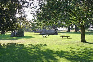
Stockwood Park is a large municipal park near Junction 10 of the M1 motorway. The park houses the Stockwood Craft Museum, the Mossman Collection and the period formal gardens which are all free of charge for visitors. There is an athletics track, an 18-hole golf course, several rugby pitches and areas of open space.
The park was originally the estate and grounds to Stockwood House, which was demolished in 1964.
Luton Carnival
Luton Carnival is the largest one-day carnival in Europe. It usually takes place on the late May Bank Holiday. Crowds can reach 150,000[21] on each occasion.
The procession starts at Wardown Park and makes its way down New Bedford Road, around the Town Centre via St George's Square, back down New Bedford Road and finishes back at Wardown Park. There are music stages and stalls around the town centre and at Wardown Park.
Museums
Luton Museum
Luton Museum and Art Gallery is housed in a large Victorian mansion in Wardown Park on the outskirts of the town centre. The focus of the museum collection is the traditional crafts of Bedfordshire, notably lace-making and hat-making. There are samples of local lace from as early as the 17th century.
The Wenlock Jug, a rare example of a jug cast, was almost sold to New York's Metropolitan Museum of Art for £750,000 but was export-stopped in October 2005 by the then culture minister.
Stockwood Craft Museum
Based in Stockwood Park, Luton, the collection of rural crafts and trades held at Stockwood Park Museum was amassed by Thomas Wyatt Bagshawe, who was a notable local historian and a leading authority on folk life. Bagshawe was born in Dunstable in 1901 and became a director of the family engineering firm.
The collection only contains examples from Bedfordshire and the borders of neighbouring counties, giving the collection a very strong regional identity.
Mossman Collection
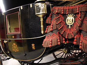
The Mossman Carriage collection is held at Stockwood Park, Luton and is the largest and most significant vehicle collection of its kind in the country, including originals from the 18th, 19th and 20th centuries.
The Mossman collection of horse-drawn vehicles was given to Luton Museum Service in 1991. It illustrates the development of horse-drawn road transportation in Britain from Roman times up until the 1930s.
References
- ↑ Luton Borough Council, 2009 Mid year population estimates for Luton.
- ↑ Central Bedfordshire Council, Central Bedfordshire's population. Dunstable 35,120. Houghton Regis 16,670.
- ↑ Dyer J, Stygall F, Dony J, The Story of Luton, Luton, 1964, p 20
- ↑ Dyer ibid, p 23
- ↑ Dyer ibid, p 31
- ↑ "Early history of Luton". http://www.localhistories.org/luton.html. Retrieved 2008-06-16.
- ↑ "Doomsday book record". http://www.domesdaybook.co.uk/bedfordshire2.html. Retrieved 2008-06-16.
- ↑ "History of St Mary's Church". http://stmarysluton.org/page2.html. Retrieved 2008-06-16.
- ↑ "Luton Castle only lasted 15 years". http://www.shoutluton.com/page8.html. Retrieved 2008-06-16.
- ↑ "Vauxhall history". http://www.vauxhallandkennington.org.uk/history.shtml. Retrieved 2008-06-16.
- ↑ "A history hat making in Luton". Plaiting and Straw Hat Making. Luton Libraries. http://www.galaxy.bedfordshire.gov.uk/webingres/luton/0.local/hat_plaiting.htm. Retrieved 2008-06-18.
- ↑ "Website of Luton Hoo Hotel Golf and Spa". http://www.lutonhoo.co.uk/. Retrieved 2008-06-18.
- ↑ "Population figures for 1801, 1901 and 1901". http://www.localhistories.org/luton.html. Retrieved 2008-06-16.
- ↑ Dyer, ibid, p 141
- ↑ Dyer, ibid, p 142
- ↑ Churchill Tanks at Vauxhall
- ↑ Deaths during WWII
- ↑ See book Luton at War volume II,compiled by The Luton News, 2001, ISBN 1-871199-49-2
- ↑ Vauxhall closure
- ↑ "Luton Council website". http://www.luton.gov.uk/internet/Leisure_and_culture/Museums_and_galleries/Wardown%20Park. Retrieved 2008-06-16.
- ↑ "Luton Carnival Coverage on the BBC". http://www.bbc.co.uk/threecounties/do_that/2004/05/carnival/carnival_day.shtml. Retrieved 2008-06-16.