Redwick, Monmouthshire: Difference between revisions
Created page with "{{infobox town | name=Redwick | county=Monmouthshire | picture=St Thomas' and museum barn, Redwick.jpg | picture caption=St Thomas' and museum barn | latitude=51.55280 | longi..." |
No edit summary |
||
| (One intermediate revision by the same user not shown) | |||
| Line 7: | Line 7: | ||
| longitude=-2.83648 | | longitude=-2.83648 | ||
| os grid ref=ST421841 | | os grid ref=ST421841 | ||
| population= | | population=218 | ||
| post town=Caldicot | | post town=Caldicot | ||
| postcode=NP26 | | postcode=NP26 | ||
| Line 14: | Line 14: | ||
| constituency=Newport East | | constituency=Newport East | ||
}} | }} | ||
'''Redwick''' is a small village and parish to the south east of the city of [[Newport, Monmouthshire|Newport]], [[Monmouthshire]]. It has a [[Redwick, Gloucestershire|namesake]] on the opposite bank of the Severn in [[Gloucestershire]]. | '''Redwick''' is a small village and parish to the south-east of the city of [[Newport, Monmouthshire|Newport]], [[Monmouthshire]]. It has a [[Redwick, Gloucestershire|namesake]] on the opposite bank of the Severn in [[Gloucestershire]]. | ||
== Location == | == Location == | ||
Redwick is located six miles south east of the city of Newport and some four miles south west of [[Caldicot, Monmouthshire|Caldicot]] on the flat coastal lands reclaimed from the [[Severn Estuary]] and [[Bristol Channel]] and part of the Caldicot and Wentloog Levels. | Redwick is located six miles south-east of the city of Newport and some four miles south-west of [[Caldicot, Monmouthshire|Caldicot]] on the flat coastal lands reclaimed from the [[Severn Estuary]] and [[Bristol Channel]] and part of the [[Caldicot and Wentloog Levels|Caldicot Level]]. | ||
== The Church == | == The Church == | ||
The ancient parish church of | The ancient parish church of St Thomas the Apostle is a Grade I listed building.<ref>{{cite web |url=http://www.britishlistedbuildings.co.uk/wa-2940-church-of-st-thomas-redwick |title=Church of St Thomas, Redwick |publisher=britishlistedbuildings.co.uk |year= |accessdate=23 November 2013}}</ref> It is notable for many unusual features.<ref>[http://www.geograph.org.uk/photo/69915 Redwick, St Thomas's Church] at geograph.org</ref><ref>{{cite web |url=http://www.newport.gov.uk/stellent/groups/public/documents/guidance_notes/cont475419.pdf |title=Church of St Thomas |publisher=Newport City Council |date= |accessdate=23 November 2013}}</ref> An earlier dedication, when it belonged to [[Tintern Abbey]], appears to have been to St Michael. It is held with [[Magor]]. | ||
The church is unusually large for a parish church on the Caldicot and Wentloog Levels, perhaps second only in its grandeur to that at Peterstone.<ref>[http://www.geograph.org.uk/photo/583085 St Thomas's Church, Redwick] at geograph.org</ref> The church has a full-immersion baptisty, unique mediæval stone carvings and a fine Victorian pipe organ salvaged from two previous churches. On the ancient south porch is a distinctive 'scratch post' or "Mass sundial" and (like the church at nearby [[Goldcliff]]) has a mark indicating the flood level of the water inundation caused by the Bristol Channel flood of 1607. The handsome font originates from the 13th century and may have been an original feature. | The church is unusually large for a parish church on the Caldicot and Wentloog Levels, perhaps second only in its grandeur to that at Peterstone.<ref>[http://www.geograph.org.uk/photo/583085 St Thomas's Church, Redwick] at geograph.org</ref> The church has a full-immersion baptisty, unique mediæval stone carvings and a fine Victorian pipe organ salvaged from two previous churches. On the ancient south porch is a distinctive 'scratch post' or "Mass sundial" and (like the church at nearby [[Goldcliff]]) has a mark indicating the flood level of the water inundation caused by the Bristol Channel flood of 1607. The handsome font originates from the 13th century and may have been an original feature. | ||
| Line 37: | Line 37: | ||
== Archaeology == | == Archaeology == | ||
Insects from samples of Bronze Age timber buildings on the foreshore at Redwick have been examined by Smith and colleagues.<ref>[http://www.arch-ant.bham.ac.uk/research/Environment/gwent.htm Institute of Archaeology and Antiquity, University of Birmingham]</ref> Four rectangular buildings of middle Bronze Age date | Insects from samples of Bronze Age timber buildings on the foreshore at Redwick have been examined by Smith and colleagues.<ref>[http://www.arch-ant.bham.ac.uk/research/Environment/gwent.htm Institute of Archaeology and Antiquity, University of Birmingham]</ref> Four rectangular buildings of middle Bronze Age date | ||
have also been excavated on inter-tidal peat at Redwick - such buildings appear to have been used during seasonal pastoral activity on the wetland.<ref>[http://www.archaeologists.net/modules/icontent/inPages/docs/ta/ta59.pdf The Archaeologist Winter 2006]</ref> Martin Bell and colleagues from the University of Reading have studied Mesolithic to Neolithic coastal environmental change at Redwick.<ref>[http://www.reading.ac.uk/SHESresearch/AllGroups/PublicationDetails.asp?grp=ASRG University of Reading Archeological Science (Geoarchaeology & Bioarchaeology)]</ref> | have also been excavated on inter-tidal peat at Redwick - such buildings appear to have been used during seasonal pastoral activity on the wetland.<ref>[http://www.archaeologists.net/modules/icontent/inPages/docs/ta/ta59.pdf The Archaeologist Winter 2006]</ref> Martin Bell and colleagues from the University of Reading have studied Mesolithic to Neolithic coastal environmental change at Redwick.<ref>[http://www.reading.ac.uk/SHESresearch/AllGroups/PublicationDetails.asp?grp=ASRG University of Reading Archeological Science (Geoarchaeology & Bioarchaeology)]</ref> | ||
Latest revision as of 15:13, 7 January 2016
| Redwick | |
| Monmouthshire | |
|---|---|
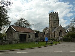
 St Thomas' and museum barn | |
| Location | |
| Grid reference: | ST421841 |
| Location: | 51°33’10"N, 2°50’11"W |
| Data | |
| Population: | 218 |
| Post town: | Caldicot |
| Postcode: | NP26 |
| Dialling code: | 01633 |
| Local Government | |
| Council: | Newport |
| Parliamentary constituency: |
Newport East |
Redwick is a small village and parish to the south-east of the city of Newport, Monmouthshire. It has a namesake on the opposite bank of the Severn in Gloucestershire.
Location
Redwick is located six miles south-east of the city of Newport and some four miles south-west of Caldicot on the flat coastal lands reclaimed from the Severn Estuary and Bristol Channel and part of the Caldicot Level.
The Church
The ancient parish church of St Thomas the Apostle is a Grade I listed building.[1] It is notable for many unusual features.[2][3] An earlier dedication, when it belonged to Tintern Abbey, appears to have been to St Michael. It is held with Magor.
The church is unusually large for a parish church on the Caldicot and Wentloog Levels, perhaps second only in its grandeur to that at Peterstone.[4] The church has a full-immersion baptisty, unique mediæval stone carvings and a fine Victorian pipe organ salvaged from two previous churches. On the ancient south porch is a distinctive 'scratch post' or "Mass sundial" and (like the church at nearby Goldcliff) has a mark indicating the flood level of the water inundation caused by the Bristol Channel flood of 1607. The handsome font originates from the 13th century and may have been an original feature.
Its embattled and pinnacled central tower contain six bells, the fourth and fifth of which are pre-Reformation bells from the Bristol foundry, dated circa 1350-80 [5] making them some of the oldest church bells working anywhere in the country. Most unusually, following their lowering in the tower in the 1990s, the bells are rung from the chancel in full view of the congregation, although a number of old unused rope bosses suggest that this must have also been the case at some time in the past. The newest bell is the treble (lightest bell) which was added in celebration of Queen Elizabeth II's 40 years on the throne.
The fine East window, which contains some painted glass from about 1870, unlike the roof and the other windows, escaped the nearby German Luftwaffe bomb blast of 1942. The restoration and re-modelling on the church, including the attractive raised tiled floor, in 1875, was by John Norton who later also participated in the building of the exquisite chapel at Tyntesfield in Somerset.
Notable features

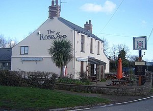
The village pub is the Rose Inn, a free house situated on South Row.[6] In May 2011, after a four-year wait, a grant of £316,323 from the Big Lottery Fund was confirmed, alongside £200,000 from the Welsh Assembly, for the replacement of the existing 60-year-old Village Hall.[7]
Whithall Farm/Redbrick House

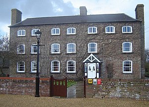
The earliest church records show that there was a house, then called Whitehall Farm, on the site since 1450. The main Georgian façade was built around 1795, by MP William Phillips. Phillips, built the Brick House ready for his son's return to Britain from the American Colonies. The son, also named William, never returned, however, as the ship carrying him home was wrecked in a storm before reaching Britain and he was drowned.[8] The house is now a guest house.
Archaeology
Insects from samples of Bronze Age timber buildings on the foreshore at Redwick have been examined by Smith and colleagues.[9] Four rectangular buildings of middle Bronze Age date have also been excavated on inter-tidal peat at Redwick - such buildings appear to have been used during seasonal pastoral activity on the wetland.[10] Martin Bell and colleagues from the University of Reading have studied Mesolithic to Neolithic coastal environmental change at Redwick.[11]
History
The church registers, which date from 1787, contain an unpleasant reminder of legal processes of not so very long ago. The last man to be hanged for sheep stealing in Monmouthshire was charged before local magistrates assembled at The Great House in the village.[12]
Salem Baptist Chapel was erected in 1832. By 1851, when the minister was Thomas Leonard, morning attendance was 21, with 13 scholars, and evening attendance was 68.[13] In 1994 the building was converted into a private residence.[1]
References
- ↑ "Church of St Thomas, Redwick". britishlistedbuildings.co.uk. http://www.britishlistedbuildings.co.uk/wa-2940-church-of-st-thomas-redwick. Retrieved 23 November 2013.
- ↑ Redwick, St Thomas's Church at geograph.org
- ↑ "Church of St Thomas". Newport City Council. http://www.newport.gov.uk/stellent/groups/public/documents/guidance_notes/cont475419.pdf. Retrieved 23 November 2013.
- ↑ St Thomas's Church, Redwick at geograph.org
- ↑ Dove's Guide: Redwick
- ↑ Rose Inn, Redwick, Monmouthshire:: OS grid ST4184 :: Geograph Britain and Ireland - photograph every grid square!
- ↑ "Joy as Redwick village hall funding approved" by Melissa Jones at southwalesargus.co.uk
- ↑ Brick House Country Guest House history
- ↑ Institute of Archaeology and Antiquity, University of Birmingham
- ↑ The Archaeologist Winter 2006
- ↑ University of Reading Archeological Science (Geoarchaeology & Bioarchaeology)
- ↑ Evans, C.J.O., (1953) Monmouthshire, Its History and Topography, Cardiff.
- ↑ Jones, I.G. and Williams, D. (1976( (eds) Church and chapel data from The Religious census of 1851: A Calendar of the returns relating to Wales, Vol 1, South Wales, Cardiff, UWP.
Outside links
| ("Wikimedia Commons" has material about Newport Redwick, Monmouthshire) |
