Welches Dam: Difference between revisions
Created page with '{{Infobox town |name=Welches Dam |county=Cambridgeshire |picture=Welches Dam.jpg |picture caption=Welches Dam |os grid ref=TL470859 |latitude=52.45098 |longitude=0.16201 |LG dist…' |
No edit summary |
||
| Line 9: | Line 9: | ||
|LG district=East Cambridgeshire | |LG district=East Cambridgeshire | ||
}} | }} | ||
'''Welches Dam''' is a hamlet and parish in [[Cambridgeshire]] around | '''Welches Dam''' is a hamlet and parish in [[Cambridgeshire]] around five miles northwest of [[Ely]]. It is to be found deep in the [[Great Fen]] beside the [[Old Bedford River]] and the parallel channel of the [[River Delph]]. The [[Forty Foot Drain]] enters the Old Bedford at Welches Dam. The nearest bridges across the [[Hundred Foot Washes]] are those at [[Mepal]] to the southwest and [[Welney]] to the northeast. | ||
The parish covers an area of 2,355 acres of the fen, and within its bounds are Welches Dam itself, and '''Purls Bridge'''. | The parish covers an area of 2,355 acres of the fen, and within its bounds are Welches Dam itself, and '''Purls Bridge'''. | ||
Latest revision as of 12:11, 24 August 2014
| Welches Dam | |
| Cambridgeshire | |
|---|---|
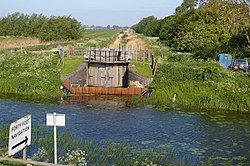
 Welches Dam | |
| Location | |
| Grid reference: | TL470859 |
| Location: | 52°27’4"N, -0°9’43"E |
| Data | |
| Local Government | |
| Council: | East Cambridgeshire |
Welches Dam is a hamlet and parish in Cambridgeshire around five miles northwest of Ely. It is to be found deep in the Great Fen beside the Old Bedford River and the parallel channel of the River Delph. The Forty Foot Drain enters the Old Bedford at Welches Dam. The nearest bridges across the Hundred Foot Washes are those at Mepal to the southwest and Welney to the northeast.
The parish covers an area of 2,355 acres of the fen, and within its bounds are Welches Dam itself, and Purls Bridge.
Welches Dam is the site of the visitor centre for the RSPB Ouse Washes reserve.[1][2]
Villages in the sourrounding fen include Coveney, Manea, Mepal, and Witcham.
History
The history of the parish is tied to that of Great Fen and the battle to drain it in the first half of the 17th century. The original principal drainage channel for the area, the Old Bedford River, runs through the parish.
The hamlet is not ancient nor is its name; it is named after Edward Welsh who built a dam across the Bedford River. Welsh was an employee of the Adventurers, the 17th century entrepreneurs who invested in the results of Cornelius Vermuyden's great work to drain the fens.[3]
Fortrey's Hall, the 17th century ancestral seat of the Fortrey family lies in the parish.
In 1849, the area became infamous after 11 of the 187 residents of the parish died in an outbreak of cholera.[3]
Church
The mission church of St Eanswythe was built in 1909.[4]