Aspenden: Difference between revisions
Jump to navigation
Jump to search
Created page with '{{Infobox town |name=Aspenden |county=Hertfordshire |picture=St Mary, Aspenden, Herts - geograph.org.uk - 355532.jpg |picture caption=St Mary, Aspenden |os grid ref=TL361282 |la…' |
mNo edit summary |
||
| Line 15: | Line 15: | ||
|constituency=North East Hertfordshire | |constituency=North East Hertfordshire | ||
}} | }} | ||
'''Aspenden''' is a village in [[Hertfordshire]], just to the south of [[Buntingford]]. | '''Aspenden''' is a village in [[Hertfordshire]], just to the south of [[Buntingford]]. The place-name is first attested in 1212 and means 'valley of aspen trees'. | ||
The [[Greenwich Meridian]] passes just to the east of Aspenden. | The [[Greenwich Meridian]] passes just to the east of Aspenden. | ||
The | The parish church is St Mary's, which is of the 13th to 16th centuries and has some fine stained glass. | ||
==Outside links== | ==Outside links== | ||
Latest revision as of 13:31, 25 May 2013
| Aspenden | |
| Hertfordshire | |
|---|---|
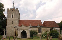
 St Mary, Aspenden | |
| Location | |
| Grid reference: | TL361282 |
| Location: | 51°56’8"N, 0°1’9"W |
| Data | |
| Population: | 222 (2001) |
| Post town: | Buntingford |
| Postcode: | SG9 |
| Dialling code: | 01763 |
| Local Government | |
| Council: | East Hertfordshire |
| Parliamentary constituency: |
North East Hertfordshire |
Aspenden is a village in Hertfordshire, just to the south of Buntingford. The place-name is first attested in 1212 and means 'valley of aspen trees'.
The Greenwich Meridian passes just to the east of Aspenden.
The parish church is St Mary's, which is of the 13th to 16th centuries and has some fine stained glass.
Outside links
| ("Wikimedia Commons" has material about Aspenden) |
References

This Hertfordshire article is a stub: help to improve Wikishire by building it up.
