Willingham
| Willingham | |
| Cambridgeshire | |
|---|---|
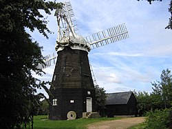
 Cattell's Mill, Willingham | |
| Location | |
| Grid reference: | TL408707 |
| Location: | 52°19’12"N, -0°4’12"E |
| Data | |
| Population: | 3,900 (2007 est.) |
| Postcode: | CB24 |
| Dialling code: | 01954 |
| Local Government | |
| Council: | South Cambridgeshire |
Willingham is a village in Cambridgeshire, on the edge of the Great Fen, just south of the Great Ouse. Driving north from the village one may observe the characteristic elevated straight roads and black soil.
The village is to be found some 12 miles northwest of Cambridge, on the B1050 road. The Parish of Willingham occupies 4,641 acres into the fen, and had a population in 2007 of 3,900 people. The highest point in the village is only about 23 feet above sea level; a lofty heigh compared with much of the land around it.
History
Willingham's history is closely associated to its position on the edge of the Fens and it was only with the major efforts to drain the Fens during the 17th century that the parish took its modern structure. During the Middle Ages, the majority of the low-lying land in the parish was inundated annually, and the village had two permanent meres, with the larger of the two growing to 380 acres at times of highest water level. It was only with the construction of the sluice at Earith in 1650 which diverted the flow of the Ouse from the Old West into the New Bedford River that the parish was able to remain largely unflooded. Additional areas were drained by windmills until replaced by steam pumps in the mid-19th century.[1]
The area at the edge of the fens to the north of the present village was already occupied by the 2nd century, though these were at some point abandoned. The Aldreth causeway, which formed the main route between Cambridge and Ely in mediæval times and perhaps dating from the Bronze Age, runs through the east of the parish past Belsar's Hill, and until the opening of the Cambridge-Ely turnpike in 1768, carriage traffic would have run through Willingham.[1]
Willingham has almost always been one of the most populous villages in Cambridgeshire. Registered population grew from 23 at the time of the Domesday Book in 1086 to 79 in 1251, and in 1377 the poll tax was paid by 287 adults. By 1801 the population was almost 800 inhabitants growing to more than 1,600 in 1851 despite a wave of emigration to America in the 1830s. Numbers then remained generally constant until the 1960s when it grew rapidly again, and passing 2,500 by 1981 and 3,436 in 2001.[1][2]
In 1940 a German spy parachuted into Willingham, was eventually captured and turned into a double agent.[3]
Name
The name 'Willingham' is Old English, probably Wifelingaham, which would mean "Wifel's clan's homestead". It appears as Vuivlingeham around 1050 and Wivelingham in the Domesday Book. The name Wivelingham was also used to refer to the village until the 18th century.[1][4]
Church
Evidence of Christian Anglo-Saxon activity in Willingham has been found, and there has probably been a church in the village since at least the 12th century.
The present parish church of St Mary and All Saints was built on the foundations of the 12th century building. Mainly constructed in the 14th century, it consists of a chancel with north vestry, nave, a south porch and a west tower with an unusual spire. It has notable 14th and 15th century figure paintings including a rare picture of a pregnant Virgin Mary.[1]
Village life
Willingham is well-served with facilities and has a primary school, library, surgery, post office and a number of shops and restaurants.
There are three pubs in the village — the Duke of Wellington, The Bank and The Black Bull. (The Three Tuns is now an Indian restaurant.) The first recorded alehouses were the George in 1665 and the Five Bells in 1671 though by the late 19th century the number had risen to 16 with the George and the Vine the most notable. The White Hart opened in 1910; there were still 7 pubs in 1933 and 5 in 1982, of which the oldest was the Duke of Wellington (known as the Warriors in the 18th century).[1]
Transport links nearby include the A14 trunk road and the Cambridgeshire Guided Busway (opened in 2011). The Great Ouse, also known hereabouts as the Old West River, is less than 2 miles away, forming part of an extensive river network of almost 200 miles of navigable river popular with boat owners.
Villages adjacent to Willingham include Over, Rampton, Longstanton and Bar Hill, and Earith in Huntingdonshire.
Outside links
| ("Wikimedia Commons" has material about Willingham) |
References
- ↑ 1.0 1.1 1.2 1.3 1.4 1.5 A History of the County of Cambridge and the Isle of Ely: Volume 9: Chesterton, Northstowe, and Papworth Hundreds
- ↑ 2001 Census
- ↑ The Spy Who Turned
- ↑ A.D. Mills (1991). The Popular Dictionary of English Place Names. Paragon Press.