Whitley, Berkshire
| Whitley | |
| Berkshire | |
|---|---|
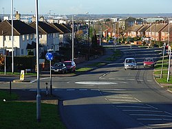
 View down Hartland Road | |
| Location | |
| Grid reference: | SU723704 |
| Location: | 51°25’41"N, -0°57’41"W |
| Data | |
| Local Government | |
| Council: | Reading |
| Parliamentary constituency: |
Reading West |
Whitley is a Berkshire village which has become a suburb of Reading.
Geography
Whitley is known as one of the larger suburbs of Reading. It is bounded to the north and east by a ridge of high ground carrying the road to Shinfield, to the west by the valleys of the River Kennet and the Foudry Brook, and to the south by an ill-defined boundary with the suburb of Whitley Wood.
The former main road to Basingstoke passes just to the west of the centre of Whitley, dividing largely residential areas to its east from a largely industrial zone to its west. The current A33 relief road to Basingstoke passes to the west of the industrial area, as does the parallel railway line. Between the relief road and Bennet Road and railway can be found the recent Green Park business park and the Madejski Stadium.
| ("Wikimedia Commons" has material about Whitley, Berkshire) |