West Kington, Wiltshire
| West Kington | |
| Wiltshire | |
|---|---|
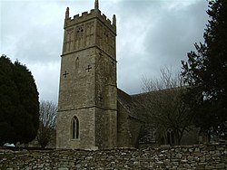
 St Mary the Virgin parish church | |
| Location | |
| Grid reference: | ST811774 |
| Location: | 51°29’43"N, 2°16’21"W |
| Data | |
| Post town: | Chippenham |
| Postcode: | SN14 |
| Dialling code: | 01249 |
| Local Government | |
| Council: | Wiltshire |
| Parliamentary constituency: |
North Wiltshire |
West Kington is a village in the west of Wiltshire, close to the border of Gloucestershire, half a mile from Nettleton (to whose civil parish it is allocated). The village is in the steeply wooded valley of the Broadmead Brook, a source of the Bybrook River.
West Kington is six miles south-east of the nearest market town, Chipping Sodbury in Gloucestershire.
There is a hamlet, West Kington Wick, half a mile south-east of the village.
Buildings
The parish church, St Mary the Virgin, has a 13th and 15th century west tower.[1] The rest of the church was rebuilt in 1856 to designs by the architect Samuel Burleigh Gabriel of Bristol. It is a Grade II* listed building.[2]
The farmhouse called Latimer Manor dates from the 16th century and is also Grade II* listed.[3] It is believed to be named after Hugh Latimer, the Protestant martyr, who had the living of West Kington in the early 16th century.
References
- ↑ Nikolaus Pevsner: The Buildings of England: Wiltshire, 1963; 1975 Penguin Books ISBN 978-0-300-09659-0page 564
- ↑ National Heritage List 1022974: Church of St Mary, West Kington (Grade II* listing)
- ↑ National Heritage List 1183476: Latimer Manor, West Kington (Grade II* listing)