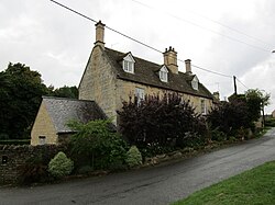
Weldon, Northamptonshire
| Weldon | |
| Northamptonshire | |
|---|---|
 Church Street, Weldon | |
| Location | |
| Grid reference: | SP928895 |
| Location: | 52°29’45"N, -0°37’59"W |
| Data | |
| Population: | 2,099 (2011) |
| Post town: | Corby |
| Postcode: | NN17 |
| Dialling code: | 01536 |
| Local Government | |
| Council: | North Northamptonshire |
| Parliamentary constituency: |
Corby |
Weldon is a suburban village on the eastern outskirts of Corby in Northamptonshire. It is two miles from Corby town centre. It stands at the crossroads of the north–south A43 trunk road, which bypasses it to the west, and the A427 which, locally, provides a route to Market Harborough westbound and Oundle eastbound.
The parish church, St Mary the Virgin, is an early-13th century limestone-built church and is located just to the south of the main village.
Weldon currently has two public houses; The Shoulder of Mutton and The George, formerly a 17th-century coaching inn. The King's Arms was demolished and replaced with housing.
History
The village is listed in the Domesday Book as Weledene. The head of the manor before 1066 is listed as 'Weldon'. The Lord in 1066 is listed as 'Northmann', perhaps an unnamed Viking or Dane. The Lord, and Tenant-in-Chief, in 1086 was Robert de Bucy (Buci), a Norman.
The village's name means 'hill with a spring/stream'.[1]
The 2011 Census recorded a population of 2,099.
Sport
Outside links
| ("Wikimedia Commons" has material about Weldon, Northamptonshire) |