Weedon
- Not to be confused with Weedon Bec
| Weedon | |
| Buckinghamshire | |
|---|---|
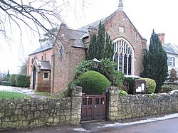
 Chapel at Weedon | |
| Location | |
| Grid reference: | SP814181 |
| Location: | 51°51’21"N, -0°49’10"W |
| Data | |
| Population: | 275 (2011) |
| Post town: | Aylesbury |
| Postcode: | HP22 |
| Dialling code: | 01296 |
| Local Government | |
| Council: | Buckinghamshire |
| Parliamentary constituency: |
Buckingham |
Weedon is a village to the north of Aylesbury and south of Hardwick in Buckinghamshire.
The village's name is said by some to be derived from the Old English for "hill with a heathen temple". In records dated 1066 the village was recorded as Weodune.
Weedon has a Methodist Chapel and a pub called the Five Elms. To the east of the village is the hamlet of East End.
Portions of the village (and later parish) have been subject to human settlement since the early Bronze Age, with excavations in the early 2000s suggesting that a field system was in operation, and later Roman settlement has also been identified. Some Neolithic flint working has been recovered but there is no indication of anything more than low-level activity.
Housing development
Prior to 2011 land within the parish southwest of the village and adjoining the northern edge of Aylesbury was designated a 'major development area', to be called Weedon Hill. When completed the housing development will include 850 houses, a local centre and a secondary school.
Additionally, an extension of the Chiltern Line was constructed which included a new station, opened in 2008, called Aylesbury Vale Parkway.
Outside links
| ("Wikimedia Commons" has material about Weedon) |