Todber
Jump to navigation
Jump to search
| Todber | |
| Dorset | |
|---|---|
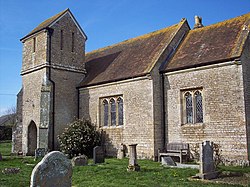
 Parish church of St Andrew, Todber | |
| Location | |
| Grid reference: | ST800200 |
| Location: | 50°58’44"N, 2°17’13"W |
| Data | |
| Population: | 140 |
| Post town: | Sturminster Newton |
| Postcode: | DT10 |
| Local Government | |
| Council: | Dorset |
| Parliamentary constituency: |
North Dorset |
Todber is a village in Dorset, in the Blackmore Vale, about five miles south-west of Shaftesbury.
The 2011 census noted that the parish had 55 households and a population of 140.
The parish church, St Andrew's, was rebuilt in the Early English and Perpendicular Gothic styles in 1879, though the tower is of earlier construction.[1]
In 1086 Todber was recorded in the Domesday Book as Todeberie.[2] The lord was Geoffrey Mallory and the tenant-in-chief was William of Mohun. It had one mill, 12 acres of meadow and 2 ploughlands.[3]
Outside links
| ("Wikimedia Commons" has material about Todber) |
- St Andrew's, Todber: Stour Vale Churches
References
- ↑ "Todber". Dorset OPC Project. 2013. http://www.opcdorset.org/TodberFiles/Todber.htm. Retrieved 18 November 2013.
- ↑ "Dorset S-Z". The Domesday Book Online. domesdaybook.co.uk. http://www.domesdaybook.co.uk/dorset3.html. Retrieved 7 February 2015.
- ↑ "Place: Todber". Open Domesday. domesdaymap.co.uk. http://domesdaymap.co.uk/place/ST7920/todber/. Retrieved 7 February 2015.