Thrupp, Oxfordshire
| Thrupp | |
| Oxfordshire | |
|---|---|
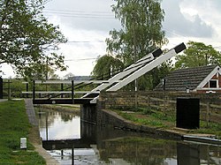
 Lift Bridge over the Oxford Canal at Thrupp | |
| Location | |
| Grid reference: | SP4815 |
| Location: | 51°50’20"N, 1°18’11"W |
| Data | |
| Post town: | Kidlington |
| Postcode: | OX5 |
| Dialling code: | 01865 |
| Local Government | |
| Council: | Cherwell |
| Parliamentary constituency: |
Banbury |
Thrupp is a hamlet just north of Kidlington in Oxfordshire. It is beside the Oxford Canal and close to the River Cherwell.
Thrupp has no parish church of its own but falls within the Church of England parish of Parish of Shipton on Cherwell. In 1876 Woodstock Baptist Church converted a house in Thrupp into a chapel. In 1953 the Baptists built a new church in nearby Kidlington, and in 1954 Thrupp chapel was consequently closed and sold.[1] It has since been converted back into a house,[2] but retains the external appearance of a chapel that it acquired in 1876. The 15th century cross, which may have originally stood on the main Banbury Road, now stands in front of the former chapel.
At the end of the road through Thrupp is a drawbridge across the canal. On the other side is a yard with three cottages with a common thatched roof. These cottages and the yard belong to the British Waterways Board, inherited from the canal company: the cottages were used by canal employees.
Thrupp was used as a picturesque setting for an episode of the popular television series "Inspector Morse". Scenes were shot near the canal and the Boat House public house during 1989.
History
Before the Norman conquest of England in 1066 the manor of Thrupp belonged to Stigand, Archbishop of Canterbury. In 1070 Stigand was deposed and King William confiscated his lands. William granted Thrupp to Roger d'Ivry, who sold it to Wadard, a knight in William's court.[3] In 1086 Thrupp was such a small settlement that the Domesday Book did not record it as having any tenants.[4]
Thrupp has the remains of a 15th-century cross carved from local Jurassic limestone. The cross itself has been lost, but the base and rather weathered shaft survive.[5]
The present Manor Farm buildings date from the early part of the 17th century. As well as the farmhouse there are a granary and dovecote from the same period.[6] The farm used to have a watermill powered by the River Cherwell.[5]
In 1788 the Oxford Canal was extended southwards from Northbrook Lock just north of Tackley towards Kidlington and Oxford.[7] It is taken roughly parallel to the River Cherwell until Thrupp, where it turns away from the river in a right-angle around Manor Farm in order to approach Oxford along the valley of the River Thames rather than that of the Cherwell. The canal company bought the manorial watermill, demolished most of it, and built a row of cottages beside the canal in its place. They used to be called Salt Row, and one historian suggests that they served as salt warehouses.[8]
In the 18th century Thrupp had two public houses: the Axe which is now the Boat Inn, and the Three Horseshoes which closed in 1924. In the 20th century the Britannia opened on the main Banbury Road and has since been renamed the Jolly Boatman.
Sources
- Cherwell District Council (August 2007). Hampton Gay, Shipton-on-Cherwell and Thrupp Conservation Area Appraisal. Banbury: Cherwell District Council. pp. 25–27.
- Compton, Hugh J. (1976). The Oxford Canal. Newton Abbot: David & Charles. ISBN 0 7153 7238 6.
- Crossley, Alan & Elrington, C.R.; A.P. Baggs, W.J. Blair, Eleanor Chance, Christina Colvin, Janet Cooper, C.J. Day, Nesta Selwyn, S.C. Townley (2007). Victoria County History: A History of the County of Oxford: Volume 12 Wootton Hundred (South) including Woodstock. pp. 210–211.
- Richards J. (1971). Thrupp, a study of the "isolated beauty" of the industrial revolution.
Outside links
| ("Wikimedia Commons" has material about Oxfordshire Thrupp, Oxfordshire) |

References
- ↑ Crossley & Elrington, 2007, pages 210-211
- ↑ Cherwell District Council, 2007, page 24, section 9.2.6
- ↑ Cherwell District Council, 2007, page 24, section 9.2.1
- ↑ Cherwell District Council, 2007, page 24, section 9.2.3
- ↑ 5.0 5.1 Cherwell District Council, 2007, page 26, section 10.8
- ↑ Cherwell District Council, 2007, page 25, section 10.3
- ↑ Compton, 1976, page 37
- ↑ Richards J, 1971, cited in Cherwell District Council, 2007, page 25, section 10.3