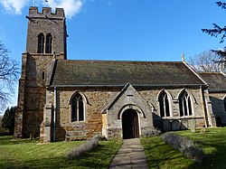
Stoke Albany
Jump to navigation
Jump to search
| Stoke Albany | |
| Northamptonshire | |
|---|---|
 St Botolph's Church, Stoke Albany | |
| Location | |
| Grid reference: | SP807878 |
| Location: | 52°28’56"N, -0°48’47"W |
| Data | |
| Population: | 390 (2011) |
| Post town: | Market Harborough |
| Postcode: | LE16 |
| Dialling code: | 01858 |
| Local Government | |
| Council: | North Northamptonshire |
| Parliamentary constituency: |
Kettering |
| Website: | Stoke Albany Parish Council |
Stoke Albany is a village in Northamptonshire, lass that half a mile west of neighbouring Wilbarston, off the A427 road between Market Harborough and Corby, about halfway between the two.
The 2011 Census recorded the population of the parish (including Brampton Ash and Little Bowden) as 390.
The parish church, St Botolph's, is a Grade II* listed building.
The village was held by William de Albinni in 1155.
Outside links
| ("Wikimedia Commons" has material about Stoke Albany) |
References
This Northamptonshire article is a stub: help to improve Wikishire by building it up.