Sorbie
| Sorbie | |
| Wigtownshire | |
|---|---|

| |
| Location | |
| Grid reference: | NX437468 |
| Location: | 54°47’31"N, 4°25’56"W |
| Data | |
| Post town: | Newton Stewart |
| Postcode: | DG8 |
| Local Government | |
| Council: | Dumfries and Galloway |
| Parliamentary constituency: |
Dumfries and Galloway |
Sorbie is a small village in Wigtownshire, on the Machars peninsula, mid-way on the A714 road from Wigtown south to Whithorn. It is a farming parish first and foremost.
Churches
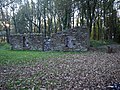
Sorbie Parish Church, in the centre of the village, dates from around 1755 and is a large T-plan structure, now de-roofed.
Millisle Church, half a mile west of Garlieston, was designed by Alan Stewart, the 10th Earl of Galloway (1835 - 1901).
History
Sorbie parish was a seventeenth-century amalgamation of Sorbie, Kirkmadrine and Cruggleton. Timothy Pont's 17th century map shows Kirck of Cruggeltown [1][2]
Ainslie's 1782 map shows Sorby Parish and the church by the Village of Sorbie [3]
Cruggleton Castle which was abandoned in the 17th century, is a few miles south of Garlieston.[4]
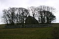
Sorbie Tower, one mile east of the village of Sorbie, was the seat of the Clan Hannay.
There is an early mediæval motte near Sorbie Tower.[5]
A junction on the Wigtownshire Railway opened in Millisle in 1876. Sorbie station on the Wigtownshire Railway branch of the Portpatrick and Wigtownshire Joint Railway, which branch closed in the 1964, formerly served Sorbie village.
For many years Sorbie had a creamery located beside the railway station, some of whose products were once exported via the port at nearby Garlieston. The creamery finally closed in the 1990s and the site occupied by a granite works.
About the village
Galloway House, the seat of the Earl of Galloway, is a stately mansion erected about the middle of the 18th century, and situated on the nearby coast between Garliestown Bay and Rigg Bay.[6] Located within Galloway House Gardens are the ruins of a few cottages. The cottages mark the site of Carswell village that was situated in Rigg Bay. When the Earl of Galloway decided he wanted to build a grand new house called Galloway House close by, he moved the people from Carswell.
In west Sorbie is the site of Dowalton Loch, also called Ravenston and Longcastle. The loch was about 3 miles in circumference and from six to twenty feet deep which, when drained, was found to contain two small islands or lake dwellings of the pre-historic inhabitants. Five canoes were found in the loch. On the islands, and in their neighbourhood were also discovered several vessels of bronze, beads of glass, vitreous paste and amber, querns, whetstones, etc. (Ref. Dr. Stuart's address to the Archaeological Society of Glasgow, 1865-6).[7]
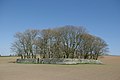
Doon Hill fort or settlement is found just below the highest point of Doon Hill consisting of two earthen ramparts with a medial ditch. The dimensions and form of the earthwork, together with its situation on sloping ground, place it in a class common in Wigtownshire.[8][9]
Eggerness, a headland near Sobie, has an Iron Age promontory fort[10]
Big society
Voluntary and social groups thrive in Sorbie, and Sorbie Village Hall is used by a number of them.
Pictures
-
 Galloway Granite Works, formerly a creamery
 -
 Cruggleton Chapel, built 1875
 -
 restored 12th century Cruggleton Church afterwards Sorbie Church
 -
 Restored Cruggleton Church, afterwards Sorbie Church
 -
 Sorbie, old Parish Church ruin
 -
 Sorbie, restored church
 -
 Sorbie Parish Church
 -
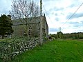
 Carswell Village
 -
 Site of Dowalton (Longcastle) Loch
 -
 Dwelling site in Sorbie, Dowalton Loch
 -
 Motte at Sorbie tower
 -
 Eggerness Castle
 -
 Innerwell Port


| ("Wikimedia Commons" has material about Sorbie) |
References
- ↑ http://maps.nls.uk/atlas/blaeu/view/?id=95#id=95&zoom=5&lat=2615&lon=5209&layers=BT
- ↑ http://www.whithorn.info/community/sorbie.htm
- ↑ http://maps.nls.uk/counties/view/?id=685#id=685&zoom=6&lat=4292.96117&lon=12572.44175&layers=BT
- ↑ http://www.scottish-places.info/towns/townmap3221.html
- ↑ http://canmore.rcahms.gov.uk/en/site/63151/details/sorbie+motte/
- ↑ A Topographical Dictionary of Scotland, Samuel Lewis, 1846
- ↑ Rambles in Galloway by Malcolm M'Lachlan Harper. pub. 1876 http://archive.org/stream/ramblesingallow00harpgoog#page/n292/mode/2up
- ↑ RCAHMS
- ↑ Megalithic Portal
- ↑ RCAHMS