Quarndon
| Quarndon | |
| Derbyshire | |
|---|---|
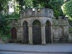
 Spring Well in Quarndon | |
| Location | |
| Grid reference: | SK334410 |
| Location: | 52°57’58"N, 1°30’11"W |
| Data | |
| Population: | 933 (2011) |
| Post town: | Derby |
| Postcode: | DE22 |
| Local Government | |
| Council: | Amber Valley |
Quarndon is a linear village in Derbyshire, spread along four minor upland roads, approximately a mile north of the Derby suburb of Allestree.
Many tourists throughout the 18th and early 19th centuries visited Quarndon's chalybeate springs within and next to its wellhouse. Many of these also sampled the waters of a geologically related spring in the grounds of its western neighbour, Kedleston Hall in Kedleston, a village with a smaller population and a single estate dominating its lands.
The vast majority of the village's buildings are residential, which spread along four minor upland roads north of Allestree, orf which two of the roads lead towards Derby.

History
A manor of Quarndon appears in the Domesday Book of 1086. This survey recorded 8 ploughlands having been held in 1066 by King Edward contemporaneously by the King who was also tenant-in-chief.
An ivy-clad bell tower marks the remains of the Norman chapel which served the community's spiritual needs until 1874. In the 1870s the village was created an ecclesiastical parish in 1732 converting the small and crumbling chapel to a church and had its forerunner replacement on the present site in 1790.[1]
Starting with a digression to the neighbouring house and park reflective of his landed class, Daniel Defoe wrote in the early 18th century:
In our way we past an antient seat [Kedleston Hall], large, but not very gay, of Sir Nathaniel Curson, a noted and (for wealth) over great family, for many ages inhabitants of this county. Hence we kept the Derwent on our right-hand, but kept our distance, the waters being out; for the Derwent is a frightful creature when the hills load her current with water; I say, we kept our distance, and contented our selves with hearing the roaring of its waters, till we came to Quarn or Quarden. a little ragged, but noted village, where there is a famous chalybeat spring, to which abundance of people go in the season to drink the water, as also a cold bath.—Daniel Defoe's Tour Through the Whole Island of Great Britain, 1726 (8)[2]
A brief extract of a large Victorian geographical, historic and economic Topographical Dictionary reads:
It comprises 790.0 acres (3.2 km²)...619 grass-land, 160½ ploughland and gardens, and 10 acres plantations...The soil in the lower part is a very rich marl, and in the higher a light dry sandy soil...the surface is undulated, and the scenery picturesque. The village, which is scattered, is considerable, being nearly a mile and a half in length; it is of pleasant appearance, and contains some very neat modern houses...church is an ancient structure, with a campanile tower nearly covered with ivy, and a Norman arch at the entrance. Sir John Curzon, in 1725, bequeathed an annuity of £20 for the support of a free school. In the village is a chalybeate spring, which was much resorted to upwards of a century since, and is still visited in summer, the water being highly beneficial in cases of debility.—Lewis, Samuel: 'A Topographical Dictionary of England' (S. Lewis and Co., 1848) pp623–4 ISBN 978-0-8063-1508-9</ref>
Parish church
The parish church, St Paul's, was built 1872–74, designed by Giles and Brookhouse in a mid-13th century style.[3][4]
The land for the church together with a contribution of £1,000 for building was given by the Reverend Alfred Curzon, 4th Baron Scarsdale. Its skeleton clock was installed in 1897 to mark Queen Victoria's Diamond Jubilee.
About the village
The ornate spring wellhouse in Quarndon is a Grade II listed structure. A plaque inside the well has the following description "17th century chalybeate spring well. Once famous spa noted for medicinal waters containing iron. Visited by Daniel Defoe in 1727".</ref>[5]
Quarndon Village Hall was built by the Curzon family (assisted with funds raised by village efforts) and opened on 9 May 1914. In 1965 and in 2004, the Hall was extended.[6]
The highest part of the parish is Quarndon Hill, a partly settled ridge of mixed woodland and common land topped by a gently winding street leading north-west.
To the south of the village is Markeaton Brook, which rises at two sources, one in the village and the other from above the lake of Kedleston Park, a large landscape garden in the neighbouring parish to the west.

On Bunkers Hill is the 'Millennium Topograph', unveiled on 29 September 2001 and funded by the will of the third Viscount Scarsdale who died in 2000. It stands on an eight-ton block of Derbyshire gritstone, at 460 feet above sea level. The directional compass points to nearly 50 places of special interest.
Society

- Cricket: Quarndon Cricket Club
- Golf: The 18-hole Kedleston Park Golf Club intrudes int the esternmost part of the parish[7]
- Amateur dramatics: Quarndon Amateur Dramatics Society, founded in 1941.
Outside links
| ("Wikimedia Commons" has material about Quarndon) |
- Quarndon on Visit Derbyshire
- Information on Quarndon from GENUKI
- 20 photographs of Quarndon
- Quarndon Parish Council
- Quarndon Amateur Dramatic Society
- Quarndon Pre-School
References
- ↑ Vision of Britain
- ↑ Daniel Defoe: 'A tour thro' the whole island of Great Britain, divided into circuits or journies': Letter 8, Part 2: The Peak District
- ↑ Quarndon St Paul: Church Near You
- ↑ National Heritage List 1109102: Church of St Paul (Grade II listing)
- ↑ National Heritage List 1311372: Chalybeate Wellhouse (Grade II listing)
- ↑ A Brief History of Quarndon: Quarndon Parish Council
- ↑ Kedleston Park Golf Course