Port Carlisle
| Port Carlisle | |
| Cumberland | |
|---|---|
 The Hope and Anchor, Port Carlisle | |
| Location | |
| Grid reference: | NY241622 |
| Location: | 54°56’53"N, 3°11’10"W |
| Data | |
| Post town: | Wigton |
| Postcode: | CA7 |
| Dialling code: | 016973 |
| Local Government | |
| Council: | Cumberland |
| Parliamentary constituency: |
Workington |
Port Carlisle is a fishing village in northern Cumberland, to the west of Carlisle and just a mile from Bowness-on-Solway. In its high days it was a brisk port for the county town from which it takes its name, but those days were brief.
History
The village's original name was Fisher's Cross. A port was built here in 1819 to serve Carlisle and four years later, a canal link was added to take goods to Carlisle Basin. The canal was closed in 1853 and Port Carlisle silted up.
The canal basin at Carlisle and parts of the canal were filled in by the Port Carlisle Railway Company who constructed a railway that started passenger services in 1854, discontinuing them two years later when the railway to Silloth opened. As a cheap alternative, a horse-drawn service was provided in 1856 between Drumburgh and Port Carlisle railway station for a number of years. In 1914 steam power was used, and to try to avoid closure a steam railmotor called 'Flower of Yarrow' was built and this service to Port Carlisle railway station lasted until the branch was closed in 1932.[1]
-
 Port Carlisle railway station remnants
 -
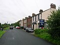 Port Carlisle's main street
 -
 Port Carlisle Methodist chapel


Outside links
| ("Wikimedia Commons" has material about Port Carlisle) |
- Footage of the harbour and canal dock - YouTube