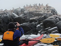
Pléneau Island
Jump to navigation
Jump to search
| Pléneau Island | |

| |
|---|---|
| Location | |
| Location: | 65°6’14"S, 64°3’20"W |
| Data | |
Pléneau Island lies to the north-east of Hovgaard Island, off the Graham Coast of Graham Land in the British Antarctic Territory.
The north-east point of the island was charted by the French Antarctic Expedition of 1903-05, and named Pointe Pléneau after Paul Pléneau, photographer on the expedition. The island was mapped by the French Antarctic Expedition of 1908-1910, as a peninsula joined to Hovgaard Island
This peninsula was charted by a Royal Navy Hydrographic Survey Unit in 1957-58, and found to be an island: the very narrow channel between Pléneau and Hovgaard was navigated by a survey launch and the name of Pléneau was retained, now for the name of the island.
References
- Gazetteer and Map of The British Antarctic Territory: Pléneau Island