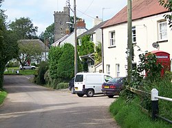
Payhembury
Jump to navigation
Jump to search
| Payhembury | |
| Devon | |
|---|---|
 Village of Payhembury | |
| Location | |
| Grid reference: | ST089016 |
| Location: | 50°48’25"N, 3°17’39"W |
| Data | |
| Population: | 682 (2011) |
| Local Government | |
| Council: | East Devon |
| Parliamentary constituency: |
Tiverton and Honiton |
Payhembury is a village in the east of Devon, about two miles west of Honiton.
The 2011 census recorded a parish population of 682. This parish is surrounded clockwise from the north by the parishes of Broadhembury, Awliscombe, Buckerell, Feniton, Talaton, Clyst Hydon and Plymtree.[1] The parish includes the hamlets of Colestocks, Lower Cheriton, Tale, and Upton.[2]
Church
The parish church is dedicated to St Mary and was mostly built in the fifteenth century.
The church includes a stone arcade made of Beer stone which has several shields including the arms of the Courtenay family, a coloured roof and sanctuary rails from the reign of Queen Anne.[3]
Outside links
| ("Wikimedia Commons" has material about Payhembury) |
References
- ↑ "Map of Devon Parishes". Devon County Council. http://www.devon.gov.uk/devon_districts_2002_.pdf. Retrieved 20 November 2016.
- ↑ "Payhembury Parish Boundary". East Devon District Council. http://eastdevon.gov.uk/media/1592892/payhembury-parish-boundary-map.pdf. Retrieved 18 January 2017.
- ↑ "Payhembury". http://www.devon.gov.uk/historicpayhembury. Retrieved 20 November 2016.