Mount Friesland
| Mount Friesland | |||
| British Antarctic Territory | |||
|---|---|---|---|
 Mount Friesland | |||
| Livingston Island | |||
| Summit: | 5,577 feet; 62°40’16"S, 60°11’14"W | ||
Mount Friesland is a mountain on Livingston Island in the South Shetland Islands, in the British Antarctic Territory. Rising to 5,577 feet, it is the highest mountain on the island.
The mountain is to be seen to the north-east of False Bay. Its north rib is connected to Pliska Ridge by Nesebar Gap on the west, and to Bowles Ridge on the north. On the east Mount Friesland is connected along a ridge to Lyaskovets Peak. On the south-southwest it is connected by a short saddle to a sharp-peaked rock-cored ice formation. The peak is heavily glaciated and crevassed, surmounting Huntress Glacier to the west, Perunika Glacier to the north-northwest, Huron Glacier to the northeast and Macy Glacier to the southeast.
This mountain was known to the nineteenth-century sealers who named it 'Peak of Frezeland', in association with the original name 'Frezeland' given to the whole island. The name went through various vaiations until it settled down to the current name. For a time it was alternatively named Mount Barnard, though this has not stuck.
History
The mountain was known to American and British sealers as early as 1820–21, and variously referred to as "Peak of Frezeland", "Friezland Peak", and "Friesland Peak". In the early 1900s the name "Barnard", applied by James Weddell in 1825 to nearby Needle Peak, was transferred to this mountain for a time, though the original name, with the spelling "Friesland", appears to have been more frequently used than any of the other versions.
Mount Friesland was charted by Discovery Investigations in 1933-35 as ' Mount Barnard'. Following air photography by the Falkland Islands and Dependencies Aerial Survey Expedition in 1956-57, and ground survey by the Falkland Islands Dependencies Survey in 1957-59, the original name in the form 'Mount Friesland' (the spelling most frequently used) was restored to the most conspicuous feature on Livingston Island. The name of C.H. Barnard in whose honout the alterantive name was chosen went to Barnard Point, in order to preserve the historical memory of the area. Barnard Pointis the nearby point on the south-east side of the entrance to False Bay.
The first ascent of Mount Friesland was made from Juan Carlos I Base on 30 December 1991 by the Catalan climbers Francesc Sàbat and Jorge Enrique. The peak was climbed and GPS surveyed by the Australian Damien Gildea and John Bath and the Chilean Rodrigo Fica on 20 December 2003, who produced a new map of the island in 2004, based on Spanish satellite imagery and their GPS data. The third ascent was made by the Bulgarians Lyubomir Ivanov and Doychin Vasilev on 15 December 2004. All these used Sàbat's and Enrique's eastern route to the peak.
-
 The main building of St Kliment Ohridski Base
 -
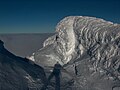
 Friesland Ridge from Bransfield Strait
 -
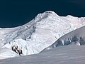 Mount Friesland from the upper Perunika Glacier
 -
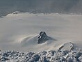
 The summit of Mount Friesland
 -
 Southern Hurd Peninsula from Mount Friesland
 -
 The Spanish base area from Mount Friesland
 -
 Bulgarian Beach from Mount Friesland


Outside links
| ("Wikimedia Commons" has material about Mount Friesland) |
- Mount Friesland. Copernix satellite image
References
- Gildea, Damien: Second Ascent of Mt. Friesland and New Altitude: American Alpine Journal, 2004, Vol 46; issue 78; pages 329–331
- L. Ivanov. General Geography and History of Livingston Island. In: Bulgarian Antarctic Research: A Synthesis. Eds. C. Pimpirev and N. Chipev. Sofia: St. Kliment Ohridski University Press, 2015. pp. 17–28. ISBN 978-954-07-3939-7
- Gazetteer and Map of The British Antarctic Territory: Mount Friesland