Minard
| Minard | |
| Argyllshire | |
|---|---|
 Minard and cottages by Loch Fyne | |
| Location | |
| Grid reference: | NR979964 |
| Location: | 56°6’59"N, 5°15’7"W |
| Data | |
| Post town: | Inveraray |
| Postcode: | PA32 |
| Dialling code: | 01546 |
| Local Government | |
| Council: | Argyll and Bute |
| Parliamentary constituency: |
Argyll and Bute |
Minard is a remote village in Argyllshire, on the western shore of Loch Fyne, situated between Inveraray and Lochgilphead. Minard is 13½ miles southwest of Inveraray, at the north-western corner of Achagoyle Bay.
This is a linear village with lochside bungalows which has seen extensive building. Along the A83 road to the south is a school, church, village hall and several older cottages break up the linear aspect.[1] It was originally part of the estate of Minard Castle before it became an independent village.[2]
About the village
Minard is on the northwest corner of the rocky shallow circle of Achagoyle Bay.
The nearest large settlement is Inveraray to the north east, along the A83 road, passing Furnace and Auchindrain. To the south, the A83 follows the curves on the loch, with Lochgilphead being the biggest town in the south.
Pictures
| ("Wikimedia Commons" has material about Minard) |
-
 Kilmichael near Minard, Argyll. View of Kilmichael and Loch Fyne,Argyllshire.
 -
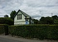 Lochfyneside parish Church, Minard, Argyll.
 -
 Lochfyneside Free Church, Minard, Argyll.
 -
 Minard Castle A view from the south and the shores of Loch Fyne.
 -
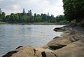
 File:Minard Point - geograph.org.uk - 461006.jpg
 -
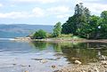
 Minard Bay A view from the Brainport Heritage Trail.
 -
 Auchgoyle Burn Outlet at Minard Auchgoyle Burn Outlet and Bridge at Minard


References
- ↑ Frank Arneil Walker (2000). Argyll and Bute. Penguin. pp. 397–. ISBN 978-0-14-071079-3. https://books.google.com/books?id=aI7RAkj0mooC&pg=PA397.
- ↑ Groome, Francis H. (1884). Jack, Thomas C.. ed. A survey of Scottish topography, statistical, biographical, and historical. Volume 6. National Library of Scotland: Grange Publishing Work. p. 34. https://digital.nls.uk/gazetteers-of-scotland-1803-1901/archive/97385414.