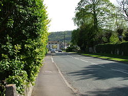
King's Stanley
| King's Stanley | |
| Gloucestershire | |
|---|---|
 Church Street, Kings Stanley | |
| Location | |
| Grid reference: | SO812038 |
| Location: | 51°43’57"N, 2°16’25"W |
| Data | |
| Population: | 2,359 (2011) |
| Post town: | Stonehouse |
| Postcode: | GL10 |
| Dialling code: | 01453 |
| Local Government | |
| Council: | Stroud |
| Parliamentary constituency: |
Stroud |
King's Stanley is a village in Gloucestershire, situated southwest of the town of Stroud. It is overlooked by Selsley common.
The village is part of what is known locally as 'The Stanleys', along with its neighbours Leonard Stanley and Stanley Downton. Stanley is recorded in the Domesday Book of 1086 as held by Turstin FitzRolf.
Marling Close, which contains the local playing fields on which the cricket and football teams play, was donated to the village by local magnates The Marlings who also helped found Marling School, and is now in the care of the Marling Trust.
Churches
The parish church, St George, is of the 12th century and is a Grade I listed building.[1]
The village is home to the oldest Baptist Church in Gloucestershire that started meeting in 1640.
Outside links
| ("Wikimedia Commons" has material about King's Stanley) |
- King's Stanley Parish Council
- A History of the County of Gloucester - Volume 10 pp 242-245: King's Stanley: Introduction (Victoria County History)
- King's Stanley on 'Stroud Voices'
References
- ↑ National Heritage List 1090720: Church of St George (Grade I listing)