Harden, Staffordshire
Jump to navigation
Jump to search
| Harden | |
| Staffordshire | |
|---|---|
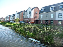
 Canalside homes on Razorbill Way, Harden | |
| Location | |
| Grid reference: | SK014013 |
| Location: | 52°36’36"N, 1°58’50"W |
| Data | |
| Local Government | |
| Council: | Walsall |
Harden is an area, once an industrialised village, to the north of Walsall in Staffordshire. It is within the Black Country conurbation: beside it are with Bloxwich, of which it has become a close suburb, and also Blakenall Heath, Coalpool, Goscote and Rushall. The whole area was part of the Industrial Revolution, with mining and metal processing being the main industries. It is close to the A34 main road from the Potteries to Birmingham and is served by canals.
The area mostly developed with council housing from the 1930s, though some of the older properties have been gradually demolished since the early 1990s.
A large area has been left as park land for community use.