Great Horwood
| Great Horwood | |
| Buckinghamshire | |
|---|---|
 The Shoulder of Mutton, Great Horwood | |
| Location | |
| Grid reference: | SP770312 |
| Location: | 51°58’23"N, -0°52’41"W |
| Data | |
| Population: | 1,049 (2011) |
| Post town: | Milton Keynes |
| Postcode: | MK17 |
| Dialling code: | 01296 |
| Local Government | |
| Council: | Buckinghamshire |
| Parliamentary constituency: |
Buckingham |
Great Horwood is a small village in the north of Buckinghamshire, with a population of about 1,025 people as in the 2001 Census. It is about five miles east of Buckingham, six miles west of Milton Keynes.
The village name 'Horwood' is Old English in origin, and means 'muddy wood'. The affix 'Great' was added later to differentiate it from the adjacent village Little Horwood. In the Anglo-Saxon Chronicle in 792 the village was recorded as Horwudu.
The village was from ancient times on the periphery of the Whaddon Chase: royal hunting land that stretched across the north part of the Aylesbury Vale. In 1447 the village was granted Royal charter to hold a weekly market, thus becoming a market town. The rents from the market were collected by New College, Oxford. Great Horwood is no longer a market town.
Great Horwood has two historic pubs: The Crown is situated on the village green and The Swan Inn on Winslow Road.
A hamlet within the parish border of Great Horwood is Singleborough.
Both Great Horwood village itself and Singleborough have Conservation Areas and there are 46 Grade II listed buildings in the Parish.
The parish church is dedicated to St James.
The village is also home to Great Horwood Church of England Combined School, which is a mixed Church of England primary school.
Pictures
-
 Entrance to Mary's
 -
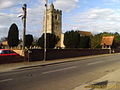 Great Horwood Church
 -
 Garages in Great Horwood
 -
 Horses seen in the village


See also
Outside links
| ("Wikimedia Commons" has material about Great Horwood) |