Gorsley Common
| Gorsley Common | |
| Herefordshire | |
|---|---|
 Gorsley Common | |
| Location | |
| Grid reference: | SO674258 |
| Location: | 51°55’48"N, 2°28’28"W |
| Data | |
| Local Government | |
| Council: | Herefordshire |
Gorsley Common is a village in the south-east Herefordshire, hard up against the border of Gloucestershire to the east. It is found immediately to the west of Gorsley and beyond it Kilcot (both in Gloucestershire) and east of Linton in Herefordshire. Little Gorsley is to the south.
The village grew around the quarries established here, and while it is a daughter village of neighbouring Gorsley, it has grown to be the larger village. It is Gorsley Common which has the village pub and the village hall, an the post office, now located within the Baptist church.
About the village
Gorsley limestone is named for the area.[1] The quarries were busy in the Victorian era, the stone going into many fine buildings of the age.[2] Victorian maps show a number of quarries and lime kilns in the area.
There is a Baptist Church in Gorsley Common. The Church of England parish church is across the county border in Gorsley, its parish encompassing both villages.
The village pub is The Roadmaker, originally named The New Inn. It is owned and run by four ex-British Army Gurkha soldiers.[3]
Gallery
-
 Gorsley Village Hall - September 2005
 -
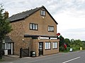 Gorsley Post Office
 -
 View to Gorsley Common
 -
 Quiz night in Gorsley Village Hall, 2008
 -
 View to Linton ridge from Gorsley Common


Outside links
| ("Wikimedia Commons" has material about Gorsley Common) |
- Gorsley Village
- Gorsley Baptist Church
- BBC Hereford & Worcester - Gorsley Flower Festival photos
- Gorsley Chapel
- Rees, Lezli: 'Walking the dog - Motorway walks for drivers and dogs', page 155 (Veloce Publishing Ltd) ISBN 978-1-84584-552-0
References
- ↑ Alfred M. Ziegler; R. B. Rickards; W. S. McKerrow (1 January 1974). Correlation of the Silurian Rocks of the British Isles. Geological Society of America. p. 46. ISBN 978-0-8137-2154-5. https://books.google.com/books?id=o7EiNhOamK0C&pg=PA46.
- ↑ Verey, David; Brooks, Alan: 'Gloucestershire: The Vale and the Forest of Dean' page 30 (Yale University Press, 2002) ISBN 978-0-300-09733-7
- ↑ The Roadmaker Inn
- Hurley, Heather: ‘The Old Roads of South Herefordshire’ (Fineleaf Editions, 2007) ISBN 978-0-9534437-4-1; pages 71–72