Gorsley
| Gorsley | |
| Gloucestershire | |
|---|---|
 Christ Church, Gorsley | |
| Location | |
| Grid reference: | SO684258 |
| Location: | 51°55’50"N, 2°27’38"W |
| Data | |
| Postcode: | HR9 |
| Local Government | |
| Council: | Forest of Dean |
Gorsley is a small village western Gloucestershire, in the Forest of Dean running up to the border of Herefordshire to the west. Immediately to the west is Gorsley Common, now the larger village, and Little Gorsley, both in Herefordshire.
The village is three miles west of Newent and six miles east of Ross-on-Wye. It is close to junction 3 of the M50, one of the first motorways built in Britain, in 1960. (The slip roads on the junction end in right angled turns which often surprise motorists used to the more gradual, modern junction designs.)
Parish church
The parish church is Christ Church. It was built in 1892 on an acre of land donated by the Onslow Trustees, at a time when the Onslow Estate owned a large part of the area and many farms and smallholdings were their tenants. The foundation stone was laid in 1892 by Miss Onslow of Newent and the stone for the building was taken from Mr. Onslow's quarry.
The parish extends over the border to encompass Gorsley Common. It is combined with Cliffords Mesne, within the Diocese of Gloucester.
A stone Baptist chapel opened in 1852.[1]
About the village
Gorsley limestone is named for the area.[2] The quarries were busy in the Victorian era, the stone going into many fine buildings of the age.[3] Victorian maps show a number of quarries and lime kilns in the area, many on the Herefordshire side.
The village pub is The Roadmaker, originally named The New Inn. It is owned and run by four ex-British Army Gurkha soldiers.[4][5]
Gallery
-
 Gorsley Village Hall - September 2005
 -
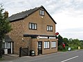 Gorsley Post Office
 -
 View to Gorsley Common
 -
 Quiz night in Gorsley Village Hall, 2008
 -
 View to Linton ridge from Gorsley Common


Outside links
| ("Wikimedia Commons" has material about Gorsley) |
References
- ↑ The Primitive Church Magazine. 1852. p. 296. https://books.google.com/books?id=eX0BAAAAQAAJ&pg=PA296.
- ↑ Alfred M. Ziegler; R. B. Rickards; W. S. McKerrow (1 January 1974). Correlation of the Silurian Rocks of the British Isles. Geological Society of America. p. 46. ISBN 978-0-8137-2154-5. https://books.google.com/books?id=o7EiNhOamK0C&pg=PA46.
- ↑ David Verey; Alan Brooks (2002). Gloucestershire: The Vale and the Forest of Dean. Yale University Press. p. 30. ISBN 978-0-300-09733-7. https://books.google.com/books?id=m9W2XH11-9EC&pg=PA30.
- ↑ "The Roadmaker Inn". http://www.theroadmakerinn.co.uk.
- ↑ Lezli Rees. Walking the dog - Motorway walks for drivers and dogs. Veloce Publishing Ltd. p. 155. ISBN 978-1-84584-552-0. https://books.google.com/books?id=JcqUepcETbMC&pg=PA155.