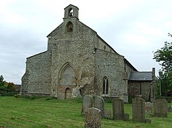
Foulden, Norfolk
| Foulden | |
| Norfolk | |
|---|---|
 All Saints Church, Foulden | |
| Location | |
| Grid reference: | TL764988 |
| Location: | 52°33’33"N, 0°36’7"E |
| Data | |
| Population: | 444 |
| Post town: | Thetford |
| Postcode: | IP26 |
| Local Government | |
| Council: | Breckland |
| Website: | Foulden Parish Council |
Foulden is a village in Norfolk. The parish of Foulden covers an area of 3,200 acres and had a population of 444 in 176 households at the 2001 census.
The name 'Foulden' is from the Old English Fugol dun, meaning "Bird Hill": it was recorded as "Fugalduna" in the Domesday Book.[1]
The village sits at the edge of Thetford Forest. Birdlife is plentiful owing to the many trees in the area, large stretches of open water, and its location near the Fens. To the north of the village is Foulden Common, a Site of Special Scientific Interest.
Local industry is primarily agricultural, including dairy farming, sugar beet and other crops.
Big Society
The village hall[2] was built in the 1970s by residents of Foulden. Today a wide range of events can be enjoyed at the hall or can be hired on a private basis.
Outside links
| ("Wikimedia Commons" has material about Foulden, Norfolk) |
References
- ↑ Eilert Ekwall, The Concise Oxford Dictionary of English Place-Names, 4th edition, 1960
- ↑ Foulden Village hall