Elm, Cambridgeshire
| Elm | |
| Cambridgeshire | |
|---|---|
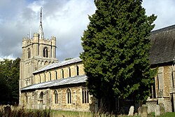
 All Saints Church, Elm | |
| Location | |
| Grid reference: | TF477062 |
| Location: | 52°37’48"N, -0°10’48"E |
| Data | |
| Population: | 3,295 |
| Post town: | Wisbech |
| Postcode: | PE14 |
| Dialling code: | 01945 |
| Local Government | |
| Council: | Fenland |
| Parliamentary constituency: |
North East Cambridgeshire |
Elm is a Fenland village in Cambridgeshire, deep in the Great Fen and sitting alongside the county boundary with Norfolk, on the outskirts of Wisbech. The northern end of Elm, alongside Elm Low Road, acts as an adjacent suburb of Wisbech.
Although close to the market town of Wisbech, Elm is has its own primary school, a post office, local shop, hairdressers, garages, and three public houses. A bus service stops in Elm, running between Wisbech and March. The nearest serviceable railway station is at March.
National Cycle Network 63 from Wisbech to Burton on Trent, passes directly through the village.
Parish church
The parish church is All Saints. It is a large pin-spired, stone building, mainly of Early English 13th-century origin.
About the village
The parish church stands prominently. Other notable local buildings include the Grade II listed Elm House, that has been dated to 1630, and the Sportsman public house, dated to the late 17th Century.
Besides allotments and market-gardening, a number of apple, pear, and plum orchards have been planted on the better drained soils close to the village centre in the north of the parish, while the lower laying peat soils further out, are cultivated as high grade arable land.
The orchards (some of which have since been replaced by new housing developments) used to attract fruit pickers from London on working holidays. After Second World War, many of these seasonal visitors would stay at a disused POW camp at Friday Bridge. The camp today is used mainly by seasonal agricultural workers from abroad.

A stream, known as The Leam, once flowed from March to Wisbech, past the church, and through the village. This stream has now been drained away, and only survives today as a pond to the south of Elm, at Friday Bridge.
History
Early penetration of the fenland around what became Elm can be traced as far as the Middle Stone Age. During the Roman period there was settlement - domestic finds of thr period have been found scattered through the parish, concentrating along the Leam stream that may have been canalised during the Roman period. There is archaeological evidence of salt processing in the Elm area too.
Drainage and falling sea levels may have prompted the settlement of Elm by the Middle Ages. In the 13th Century the parish was prosperous enough to fund the building of a significantly extravagant church. However, the lower laying parts of the parish were probably not fully drained and reclaimed until as recently as between the 17th and 19th Centuries. Later satellite settlements formed to the south of the parish at Friday Bridge and at Coldham, alongside the Leam, where land was better drained.
Elm, or Elme, once had a stop on the Wisbech and Upwell Tramway, known as Elmbridge as it was located just over the border in Norfolk near to a bridge that spanned the former Wisbech Canal. This canal connected the River Nene at Wisbech, to a junction with the Well Creek and the Old River Nene at Outwell, and passed along the northern edge of Elm.
The canal was abandoned, and finally filled in during the 1970s. Parts of it have been converted into a public green lane that starts at the post office, and terminates at the site of Collets Bridge. The tramway that ran alongside the canal was in turn closed to passengers from 1927, and finally discontinued as a freight line in 1966. It also has since been dismantled.
Outside links
| ("Wikimedia Commons" has material about Elm, Cambridgeshire) |
- Information on All Saints Church, Elm
- The Wisbech and Outwell Tramway history
- Elm website
- {{brithist|21915 Elm history]