Duckmanton
Jump to navigation
Jump to search
| Duckmanton | |
| Derbyshire | |
|---|---|
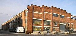
 Duckmanton Workshops. | |
| Location | |
| Grid reference: | SK448718 |
| Location: | 53°14’31"N, 1°19’44"W |
| Data | |
| Post town: | Chesterfield |
| Postcode: | S44 |
| Dialling code: | 01246 |
| Local Government | |
| Council: | North East Derbyshire |
| Parliamentary constituency: |
Bolsover |
Duckmanton is a village in north-eastern Derbyshire, found between Bolsover and Chesterfield. It is a long, scattered village, running north and south, usually designated Long, Middle and Far Duckmanton, of which Middle Duckmanton is four miles east of Chesterfield and two and a half miles west of Bolsover.
In chronostratigraphy, the British sub-stage of the Carboniferous period, the 'Duckmantian' derives its name from the study of geological exposures in a railway cutting at Duckmanton.[1]
History
Duckmanton is recorded in 1086 in the Domesday Book under the land of Ralph Fitzhubert, who held a number of manors in Derbyshire:
In Duckmanton Leofnoth had four carucates of land and two bovates to the geld with land for five ploughs. There are eighteen paying tenants with five ploughs. There are eight acres of meadow and woodland pasture one league long by one league wide. In the time of King Edward worth about four pounds now nineteen shillings. Geoffrey holds it.
References
- ↑ Cleal, C.J., Thomas, B.A., 1996 British Upper Carboniferous Stratigraphy Vol 11 of the Geological Conservation Review series